News Roundup
UAS survey first for Lloyds Building
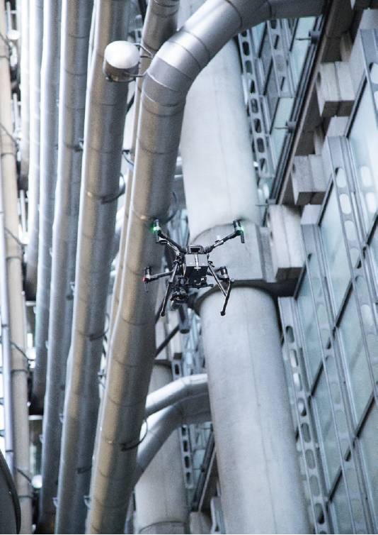 The annual survey of the Lloyd’s Building in London has been carried out by the use of a unmanned aerial system (UAS) for the first time. The survey of the Grade 1, 88m tall building, covers 4,500 linear metres of external stainless steel clad pipework and 12,000 square metres of glazing.
The Lloyd’s Building is one of the first UAS façade surveys undertaken in the City of London. Lloyd’s itself enabled the innovative approach to take place through the involvement of one of its Lloyd’s Lab start-ups providing the necessary insurance. Flock, an insurtech start-up, was part of Lloyd’s Lab in 2019 and pioneered a flexible insurance product with integrated third parties and invasion of privacy cover, facilitating commercial UAS equipment to be used for this type of work.
Arup worked with VirtuLabs to carry out the UAS survey in September 2020. VirtuLabs provided the flying expertise directed by Arup’s façade engineer. Prior to the survey approval was needed from the Civil Aviation Authority and NATS clearance. Road and pavement closure permits from the Corporation of London were also required.
The UAS survey captured around 80% of the necessary data, abseiling – the ‘traditional’ method used for data collection on the façade – will still be needed to complete the survey. Data and images from the UAS flights will be used to update the existing 3D virtual maintenance model of the building. Terry Blacker, senior facilities manager at Lloyd’s said: “The use of drones to survey our building has reduced the risk from abseiling and saved time and cost. The results are excellent. The fact that a Lloyd’s Lab alumni created the insurance policies to allow this to happen also makes us very proud.”
Global BIM Network launches
The Global BIM Network has been launched to encourage collaboration and knowledge sharing internationally in digital engineering and building information modelling (BIM). Supported by the Construction Innovation Hub and the UK government Foreign, Commonwealth and Development Office, the Global BIM Network aims to connect international public sector representatives, multi-lateral organisations and infrastructure funders to advance the digitalisation of the built environment.
Adam Matthews, Chair of the Global BIM Network said: “It’s not about anyone individual country, or any one particular region. It’s about bringing all of our learnings together and creating better outcomes for people and places. It is a collective, global view that benefits the public sector, the private sector, and a view that ultimately will improve the outcomes for the global built environment.” The Global BIM Network will guide the ongoing development of the Global BIM Platform, an open-access online repository for the public sector and infrastructure funders seeking guidance, documentation, protocols, operational manuals, evidence, tools, training materials and other resources to facilitate the strategic introduction of BIM worldwide.
Spot learns a new trick
Trimble has succeeded in a proof of concept in making the Spot robotic ‘dog’ follow an operator, eliminating the need for joystick control. Trimble worked with Piaggio Fast Forward (PFF) to integrate dynamic following technology into Boston Dynamics’ Spot robot platform. PFFtag is a smart following module prototype derived from gita, PFF’s personal cargo-carrying robot.
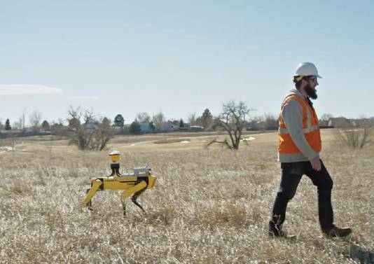 Spot was loaded with Trimble laser scanning and GNSS sensors and the PFFtag module on site in Colorado and tested for two months. Aviad Almagor, Trimble vice president for emerging technologies, said: “Like, a 21st century Sancho Panza, robots with PFFtag may have the future ability to assist construction professionals in their daily workflow, carry heavy equipment, improve efficiency and enhance workers safety. The follow-me technology by PFF provides an intuitive user experience and opens the door to collaborative robots that can augment the human workforce.”
PFF chief executive Greg Lynn said: “Most robotics companies look at the world as a world of obstacles, we adopted the opposite approach and this philosophy has fuelled our research of how humans and robots physically move through space. We design behaviours that understand people and help automate tasks so you don’t have to build complicated hardware. Working with Trimble to boost the process of replacing remote-controlled robots traveling on predetermined paths in mapped environments enables yet another step in the ultimate goal of providing safe and intuitive operations of machines in industrial environments.”
Geospatial Commission to tackle location ethics
The Geospatial Commission has begun a project looking into public attitudes about how their location data is collected and used. The commission is working with public dialogue and data specialists Sciencewise, Traverse and the Ada Lovelace Institute on the project. A series of workshops will be held with members of the public later this year.
The commission has also published its independent Planning and Housing Review, to look at how housing data is currently being accessed and used. The report identifies opportunities for better leveraging geospatial data and challenges associated with upskilling, recruiting and retaining staff with the necessary GIS, programming and data science skills.
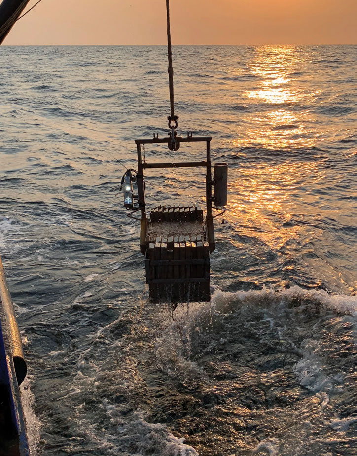
EBS in Angola
Two environmental baseline studies have been carried out offshore Angola. TDI-Brooks International carried out the studies for the Cabinda Gulf Oil Company and ExxonMobil. The studies involved water column, plankton and sediment sampling, and sediment profile and plan view imaging.