News Roundup
A new standard form of subcontract, NR23, has been added to the Network Rail suite of contracts. It is the product of a crossindustry working group that came together to respond to calls from tier 2 contractors and small to medium enterprises for a standard form of subcontract for rail aligned to Network Rail’s NR12 target cost contract.
CICES fellow Stephen Blakey, commercial project director at Network Rail, commented: “It’s a great example of how suppliers, industry bodies and Network Rail can collaborate to improve the way we work together. The new standard form will enable transparency and better alignment of expectations, promote value for money for the tax paying passenger, clarify behavioural expectations and reduce the likelihood for dispute.”
NR23 follows on from the release of NR22 and is intended for use in support of the Infrastructure Conditions of Contract (ICC), primarily its collaborative forms of contract such as the NR12.
Use of the new NR23 is intended to integrate behavioural expectations and target cost management between tier 1 and tier 2 contracts and simplify the contract review and management for tier 2s, promoting a common understanding between all parties. It also aims to promote consistency and transparency through the supply chain and provide clarity on risk allocation – promoting a stronger alignment with the main contract.
NR23 is owned and published by Network Rail and is available on the Procurement Operations Hub and Network Rail website. At the time of going to press, it was due to be launched at the CICES Commercial Management Conference on 7 October 2021.
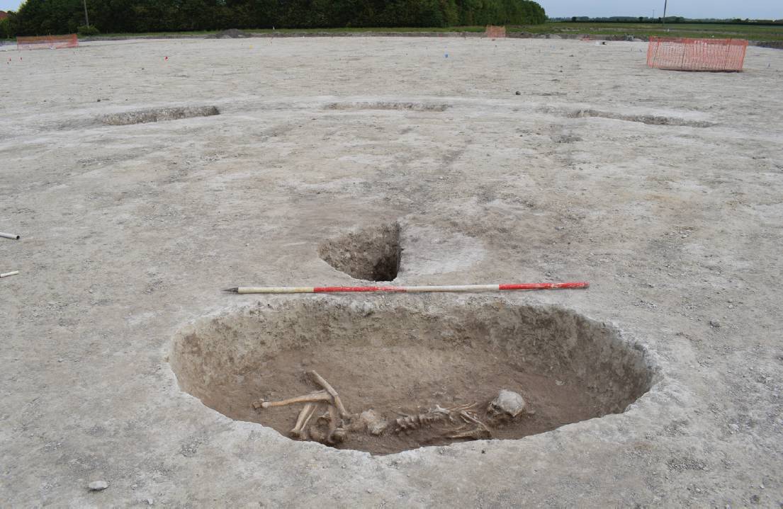
Archaeologists have unearthed human remains during the excavation of a Bronze to early Iron Age settlement, in advance of a housing development in Burwell, Cambridgeshire.
Two full human skeletons, as well as post holes, pits and pottery dating from 1200-350BC, were found at the site.
The excavation of the settlement is the first of two phases being carried by Oxford Archaeology East, supported by Cambridgeshire County Council and appointed by specialist archaeological and heritage consultants Orion.
A further area identified as a cremation burial ground will be excavated and examined ahead of phase two of the scheme. On conclusion of the archaeological dig, this Land will commence the main infrastructure for the development of 350 new homes.
Ordnance Survey (OS) has signed up to support the Locus Charter to promote the responsible use of location data. The Locus Charter is spearheaded by the American Geographical Society’s EthicalGEO and Benchmark Initiative and applies to the use of location data across all sectors including public, private, educational and not-for-profit. The aim of the charter is to promote how a shared understanding of the risks and solutions relating to uses of location data can improve standards of practice and help protect individuals and the public interest. With a wider understanding of the risks, they can be managed, and the many benefits of geospatial technologies can be amplified with endorsement from individuals and societies to improve public health, fight climate change, protect the environment and achieve positive economic outcomes
OS’s chief geospatial officer, David Henderson, said: “It is important for OS to remain at the forefront of the growing international discussion around location data ethics and play our part. As an authoritative source of location data, it is important that OS commits to using location data responsibly and ethically, and encourage others to do the same.”
Denise McKenzie, programme director of the Benchmark Initiative and chair of the Association for Geographic Information, said: “The geospatial industry today is thriving and every week we are seeing new businesses, start-ups and ventures working with location data. I want them to view the charter as a valuable guide to help and guide them as they use location data. It is pleasing to see so many established and well-respected organisations, like Ordnance Survey, already lending their support to Locus Charter. The community continues to grow and I would urge anyone working with location data to join us.”
To read the charter and join the community, visit: https://ethicalgeo.org/locus-charter/
National Highways is to create a digital twin of the roads network in England as part of its new Digital Roads 2025 strategy. The digital twin is being developed in collaboration with Costain and the University of Cambridge, funded by EU and EPSRC grants. It will see drawings and static models replaced with digital versions that can identify when maintenance is needed.
The University of Cambridge principal investigator on the project, Dr Ioannis Brilakis, said: “It is high time the transportation infrastructure sector embraces digital transformation. We should strive to replace drawings and static 3D models with dynamic and data-rich digital twins; pdf documents with databases; file exchange with cloud permissions exchange; passive materials with smart materials able to sense and heal themselves; and automate all manual routine maintenance. All this is possible on a data science foundation, able to generate rich, data-driven insights to help us make better decisions.”
Other parts of the strategy include autonomous plant, off-site fabrication, modular construction methods and an automated cone laying machine. As well as reducing disruption for drivers, these steps will reduce the associated carbon emissions by around 50% and help to meet the target of zero injuries or deaths on the network by 2040.

The 10,000th load of GGBS [ground granulated blast furnace slag] has been delivered to Hinkley Point C in Somerset.
GGBS is a replacement product for Portland cement and can significantly cut the CO2 emissions associated with concrete.
Since 2014, more than 230,000 tonnes of Regen GGBS has been supplied to EDF’s contractors from Hanson’s Port Talbot site.
The Digital Preservation Coalition (DPC) has released three new data ‘technology watch’ guidance notes. The guidance covers 3D data, CAD files and GIS data.
Authored by Artefactual Systems and developed in conjunction with the UK Nuclear Decommissioning Authority, each of the notes is designed to provide a primer on the current state of community knowledge about types of data commonly encountered by those seeking to preserve digital holdings.
Paul Wheatley, DPC head of research, commented: “There is so much information about the preservation of different types of data out there, but it can be hard for the practitioner to know where to start or to find the right resources. These notes are intended to provide a basic level of information but also point people to other useful references on the topic. We are really keen to hear feedback from the community both now and in the future so that we can maintain these notes as a useful resource for the community.”
Fugro has signed a partnership agreement with the Intergovernmental Oceanographic Commission of the United Nations Educational, Scientific and Cultural Organisation (IOC-UNESCO) to improve the coordination of and access to global ocean science data. The partnership will directly support the UN’s Decade of Ocean Science, a multifaceted initiative focused on reversing the cycle of decline in ocean health and creating improved conditions for sustainable ocean development worldwide.
Fugro will help establish and administer two ocean science data working groups to develop the Ocean Decade Data Coordination Platform, to share, manage and distribute ocean data and interoperable marine science. The company will also establish a working group of global private-sector stakeholders who collect or own ocean science data and are willing to make these data publicly accessible in support of the Ocean Decade. IOC-UNESCO executive secretary Dr Vladimir Ryabinin stated: “IOC and Fugro may be different kinds of organisations, one intergovernmental, one commercial, but we share the same ultimate goal, which is to bring ocean science and surveys to the service of the people.”
The Lego Review Board is to decide if a basement and sewerage set will make it to production. The set, designed by MOCingbird, received 10,000 votes which has pushed it to the formal review stage, where it will be assessed by lego designers and product managers, for playability and fit with the Lego brand.
MOCingbird told the Institution of Civil Engineers that the potential set would “raise awareness and recognition for all the professionals working in jobs related to planning, designing, building, running and maintaining the infrastructure of our cities. It remains to be seen what the review board will decide. Everything is possible.”

Three proposed schemes from National Highways have been created in Minecraft, for students to explore and play with. Lower Thames Crossing, A428 Black Cat to Caxton Gibbet improvements and the A303 past Stonehenge have been added to five games, along with lesson plans for key stage 2 (aged 7-11) and key stage 3 (11-14).
The five activities include building a portion of the tunnel on the Lower Thames Crossing; using MakeCode to programme road signs to respond to different scenarios on the Lower Thames Crossing; creating a stretch of road to keep animal habitats safe on the A428; going on a historic journey around Stonehenge; and exploring the biodiversity around the A303.
Each proposed scheme also has a Creative Mode for students to practice building and designing.
Megan Leckie, co-director at BlockBuilders Youth Engagement who built the games, said: “Creative platforms such as these open up a whole new world of learning for young people, where they can be directly engaged with their local environment and find out more about engineering.”
The educational package is aligned to the national curriculum and is available to teachers and schools through the Microsoft Education Centre.
In brief: Jacobs has secured 13 positions on Transport for London’s engineering consultancy framework for multidisciplinary engineering and rail services, transport and non-transport architecture and cyber security engineering.
- Pix4D has launched PIX4Dmatic 1.19 and PIX4Dsurvey 1.18 to process LiDAR and photogrammetry datasets in the same project. Both updates are being launched with a perpetual license scheme along with existing subscriptions.
- AECOM has been selected by NASA to provide services including field investigations and surveys, and scheduling and cost estimating for its US sites including the Kennedy Space Center, Johnson Space Center, and Marshall Space Flight Center.
- KOREC has delivered nine Trimble X7 3D laser scanners to Surrey Police and Sussex Police to assist in the reconstruction of serious injury and fatal collisions.
- Topcon has expanded its Topnet Live GNSS correction service. Options include Realpoint RTK and Starpoint precise point positioning.