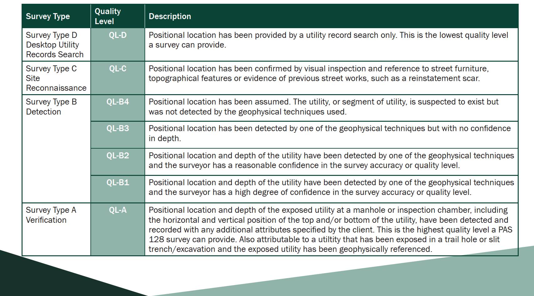
Survey Types and Quality Levels explained
Survey Type D is a prerequisite to all other survey types C, B and A being undertaken. Survey Type D data can be provided by the client (if considered robust and up-to-date by the asset owner) or can form part of a tender for other survey work (including survey types C, B and/or A).
Survey Type C can be undertaken at the same time as Survey Type B on-site. Often a surveyor will include Survey Type C within the scope for Survey Type B. However, clients should always request that Survey Type C is specified within the scope of the survey.
Survey Type B consists of a full utility mapping survey. This must include a minimum of:
- Type D and C surveys.
- Electromagnetic locator (EML) and ground penetrating radar (GPR) survey techniques.
- Other survey techniques as appropriate to the project.
- Accurate survey of located services and related infrastructure.
Survey Type A is visual identification. This can either be at a verification test hole, slit trench or excavation, or from visual inspection within chambers.
What the client needs to specify
The client should identify the accuracy they need in different areas of their site (D, C or B1, B2, B3) and the surveyor should propose a methodology which provides the best opportunity to achieve this quality level, using a combination of the different survey types and methodologies. If you have doubts about PAS 128, survey types, methodology types, and quality levels achievable, request clarification from a specialist utility surveyor. Membership of CICES and/or the Royal Institution of Chartered Surveyors (RICS) are indications of professionalism. Membership of The Survey Association (TSA), European GPR Association (EuroGPR) or being regulated by RICS indicates that a company is committed to high standards and operating in an ethical manner. Early engagement of a trusted specialist utility surveyor is key to successful survey data.
We suggest that clients make themselves familiar with Annex B of PAS 128:2022, Client guide to using the PAS 128 and Utility Surveys. This will help explain how a survey is undertaken, the methodologies used and the possible levels of quality and accuracy. Guidance notes from TSA are also helpful in this regard.
Where possible, the client should provide information on survey areas and any existing topographical data as digital files (such as CAD or GIS formats). Ambiguity in quoting can often be caused by poor quality PDF files being issued which have come from a digital form in the first place.
