Harnessing AI for efficient urban planning
Trevor Moore MCInstCES, UK Director, Exodigo
DELIVERING capital projects on time is often challenging, especially in dense, urban areas.
Rail projects in older cities are especially difficult since a web of legacy underground utilities often underlies their planned footprints.
These older lines must be found and relocated before tracks can be built, trains can run, and communities can get the transportation they need. It is widely accepted that existing statutory record information is inaccurate.
In a recent project in Birmingham in the UK, our client, Colas Rail used new artificial intelligence AI-driven technology from Exodigo to address these hidden challenges and move the critical Eastside Metro Extension project forward.
Delivering capital projects on time is often challenging, especially in dense, urban areas.As background, the metro extension is a pivotal part of the city’s broader development strategy and involves building several new light rail stations that will extend the existing metro by 1.7km towards the Curzon Street High-Speed 2 (HS2) station currently in construction, which will ultimately connect the West Midlands to the rest of the country with efficient, sustainable transportation.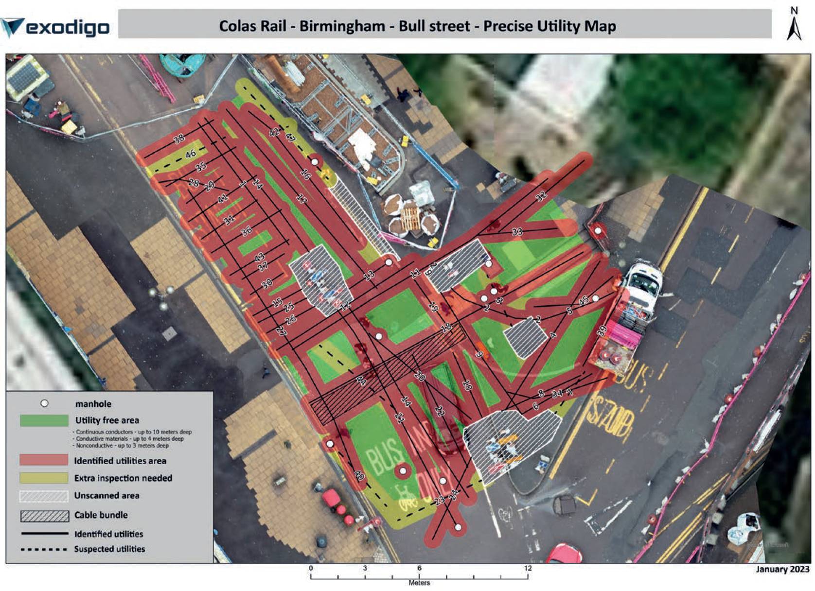
However, progress was impeded when unexpected utilities were discovered along the metro’s planned route, especially on Canal and Bull streets, threatening to delay the project timeline. Even after traditional utility surveys had been conducted, uncharted buried utilities were being found – resulting in reworks, delays, and higher project costs.
The metro expansion is a pivotal part of the city’s broader development strategy and involves building several new light rail stations that will extend the existing metro by 1.7km towards the Curzon Street High-Speed 2 (HS2) station currently in construction.The client recognised the need for a solution and so opted for our multi-sensing, AI-powered underground mapping platform. The task was to locate all utilities along the planned route to prevent further delays and ensure the smooth continuation of the project.
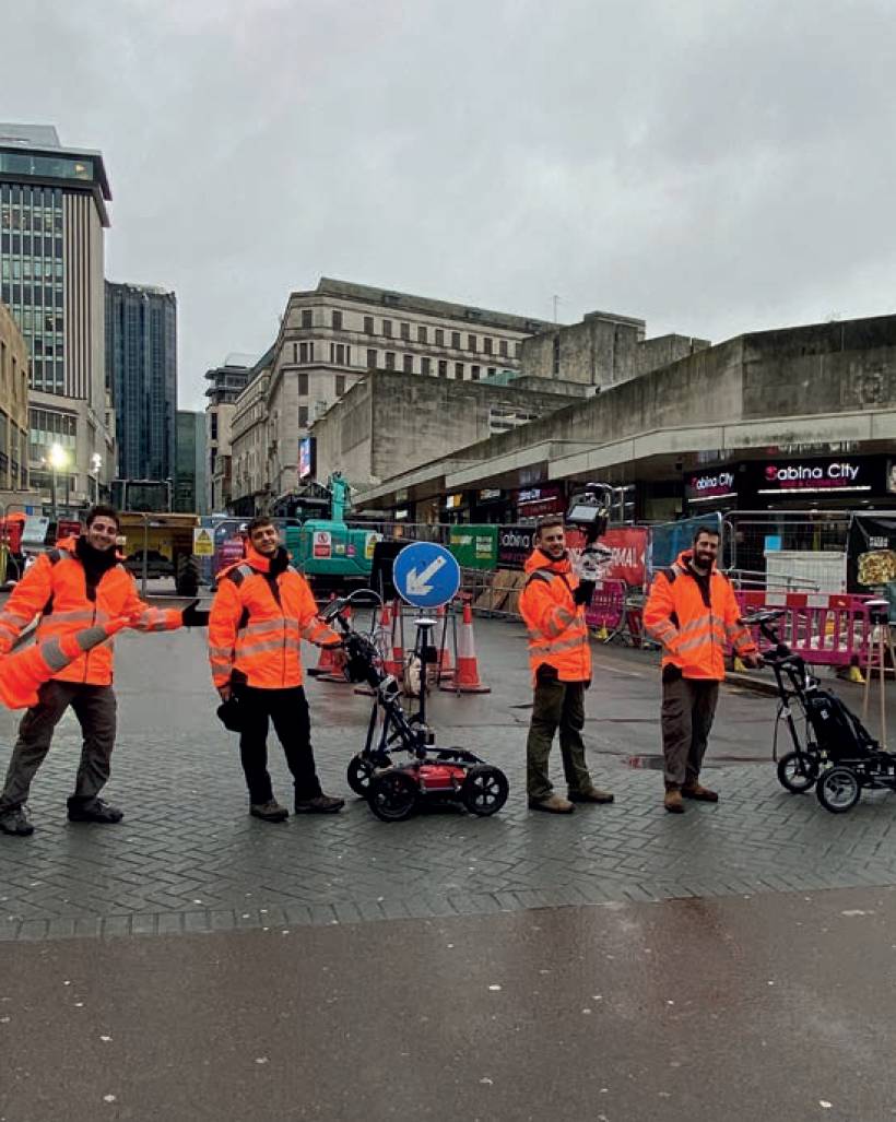
Using the technology, a comprehensive underground map was created. This was done by collecting data of the full project site over the course of a day of scanning. Every square metre of the area is scanned with a cart carrying multiple sensors in an overlapping snake pattern to cover the entirety of the area.
And while the hardware is consistently updated based on scientific advancements, the use of magnetic gradiometers and electrical simulations in time, aerial and frequency domains as well as GPR, EMR, satellite photography, and records analysis are what is currently used.
By using artificial intelligence alongside advanced geophysics, the underground mapping process removes the human bias inherent in traditional locating services that rely on visual cues to ‘follow the line’.
The use of several sensors, in parallel, and the systematic acquisition of a large amount of data on the site make it possible to detect not only traditional networks, but also networks that are more difficult to detect. This method also makes it possible to highlight not only buried networks, but also areas without networks, where digging presents no danger.
Even after traditional utility surveys had been conducted, uncharted buried utilities were being found – resulting in reworks, delays, and higher project costs.Because the platform is non-intrusive, collecting the necessary data along the proposed light rail route required minimal traffic control and didn’t disrupt the community in Birmingham’s city centre. Camera images and RTK GPS were also used to collect more than 1TB of data per hectare – more than 30 times the amount of data collected by traditional locators.
Once the data was collected, AI was used to analyse and process the insights, and turned it into a visual underground network model that allowed the client to see the underground in its entirety. This map served as a reliable guide to avoid strikes, enhance safety measures, and ensure the project’s timely completion.
In total, more than 280 utilities, including 51 that were previously undetected were identified. Several of these services were not listed on any records. Utility records are notoriously incomplete; according to the recent Digging Up Britain report1 1 from July 2023, up to 350,000km of water pipelines in the country are not mapped in records.
Unlike traditional utility mapping techniques, our aim is to map the full project site to capture all utilities without using statutory records as a starting point.
Extension projects in urban areas are frequently delayed by redesigns, but accurate underground mapping can keep them on track.
By using artificial intelligence alongside advanced geophysics, the underground mapping process removes the human bias inherent in traditional locating services that rely on visual cues to ‘follow the line’.At Canal Street, the technology detected 28 utility services missed by previous surveys, including a water pipe at a depth of 1.6m, unlisted on any records.
On Bull Street, there were also 23 previously undetected services identified, prompting the client to redesign elements of the project to avoid conflicts with existing services.
The Midland Metro Alliance is overseeing the project. It said one of its biggest risks was excavating around buried services.
The project manager, Hamish Falconer, explained that statutory plans provided by statutory undertakers were largely inaccurate.
The new surveys, therefore, provided more reliable data that could be used to select safer excavation techniques around known services.
The client is planning to use the platform on other projects throughout the UK and globally, with other engineering firms, such as Jacobs also working with us.
It is our aim to help expedite project delivery on transportation and utility projects throughout the country. This follows our UK launch in June, with our operational base now situated in London.
Our ability lies in the mapping of underground infrastructure assets, such as powerlines, pipes, bedrock, and groundwater, and it’s this ability we want to continue to expand our work on within the UK.
Trevor Moore MCInstCES, UK Director, Exodigo
---
1 See https://lsbud.co.uk/wp-content/uploads/2023/07/Digging-Up-Britain-2023.pdf