GNSS
Climbing to new heights
Determining the elevation of Mount Everest
DETERMINING the elevation of the world’s most famous mountain is not as simple as taking a GNSS receiver to the summit. The newest elevation measurements of Everest involved far more; advances in GNSS, refinements in regional geodesy and intrepid surveyors who faced perilous conditions.
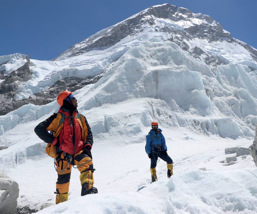
Khim Lal Gautam at Ice Fall, looking upwards to the route to Camp 1.
The challenges of the ascent were captured by chief survey officer Khim Lal Gautam, Government of Nepal:
“We faced weather problems and wind turbulence at the South Col, our last stop before the summit on 20 May 2019. And we discovered there were not enough oxygen bottles stored at the South Col for us, due to the negligence of the expedition operating company who had the responsibility for managing oxygen and other accessories. The main Sherpa of the team, Tshiring, told me that the mission was almost impossible and requested me to descend to the second camp. Having previously climbed Mount Everest, I knew that the mission would fail if we descended. I felt heartbroken at the prospect of giving up. I said to Tshiring, No! I cannot give up this historic mission at this final moment.”
Khim Lal Gautam and his team would continue up the mountain, by borrowing additional oxygen bottles. His team and their equipment performed flawlessly during the limited window for measurements despite brutal conditions on the summit. Khim Lal Gautam himself would also face a near-death situation during the descent – his firsthand account follows. But there is a backstory to this historic survey that began with broader geodetic goals in mind. GNSS receivers have been carried to the summit on many previous occasions, but never before by two successive survey teams from two countries, with the surveys registered to newly refined geodetic models and reference frameworks, and the results jointly released.
Recently announced by China and Nepal, the latest elevation for Mount Everest is more than just a number; it represents the culmination of more than 150 years of progressive advances in surveying methods and technologies since the mountain was first measured. The quality of the results is a function of how well the geodetic models of the region and Earth have been refined. Few such technical details have been discussed in mainstream news since the announcement of the new elevation, but surveyors know there is more to such an endeavour than a climb and GNSS session.
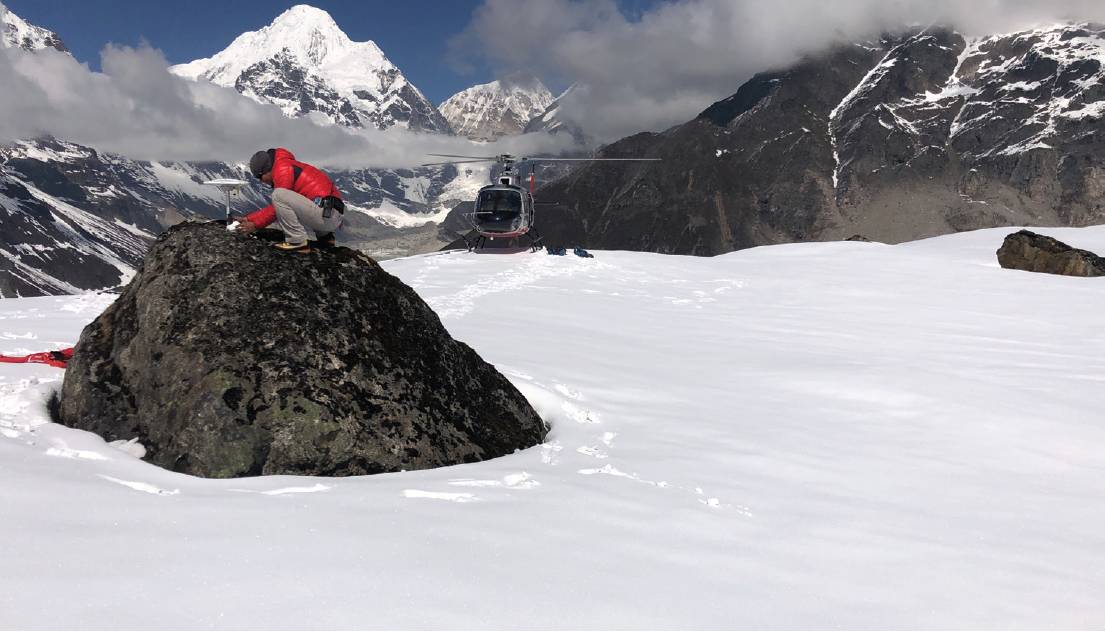
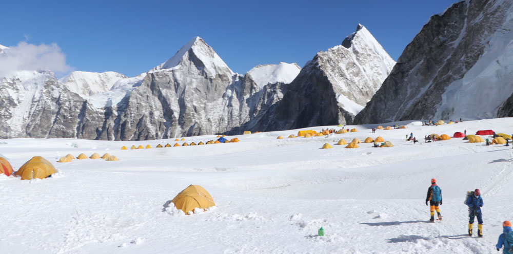
Eight temporary CORS receivers were set up on and around the mountain at elevations between 16,000-20,000ft – several were delivered by helicopter.
The arc of time
The Great Trigonometrical Survey of India spanned the years, in one form or another, from 1802 to 1871. It sought to measure and define on the ground a single arc of longitude from the southern tip of India to northern reaches in the Himalayas; this was to serve as a baseline for mapping and surveying of the (then) British colony. A series of towers were erected along the route and theodolites were hauled by crews that sometimes numbered in the hundreds.
While reducing triangulation notes in 1852, an office technician noted that one peak (known simply as PEAK XV at the time) appeared to be the tallest ever recorded, at 29,002ft. While the peak already had several local names, it was christened ‘Mount Everest’ in honour of Sir George Everest, the survey leader at the time.
Optical instruments and triangulation were the only practical methods for determining an elevation of the mountain at the time. Since then, instruments have gotten lighter and reference marks were established closer into the peak, but for over a century the method and technology changed little – until GNSS came along. In the 1990s, GNSS was brought to the summit on several occasions, and Trimble has continued to provide equipment for many of the subsequent surveys.
Notable among these surveys was the 1998 American Mount Everest Expedition, which explored multiple scientific goals; GNSS played a part in these as well. In 1998, Charlie Trimble, (founder and president of the company that bears his name) said:
“The work being done on the mountain can help us understand more about the world around us, how it changes and how the body works. This information can be applied to everyday life. The science on the mountain above 29,000 feet will have value to those of us who live at sea level.”
Four American researchers climbing Everest were fitted with bio-paks recording how their bodies reacted to the environment. That information, coupled with positioning data from the GNSS receivers, provided researchers at the base camp with the most detailed information ever compiled on the effects of altitude and climbing. On the survey side of the expedition, GNSS data was collected at four points on the mountain – Kala Pattar, Base Camp, South Col, and the summit – to precisely track the slow geological movements of the mountain over time.
In 1999, the US National Geographic Society expedition determined an elevation of 29,035ft, but in such early GNSS surveys of the summit the precision was stated as +/-6ft (a mix of expected error and geodetic reference uncertainty).
Other surveys concurred closely in 2005, 2013 and 2015. During this same period, multiple entities such as the United States Geological Survey (USGS) and the science non-profit UNAVCO established reference stations throughout the region to study earthquakes and plate tectonics. These stations also provided reference data for post-processing of several summit surveys.
As we know, GNSS only yields an ellipsoid height; a geoid model, derived from gravity observations, must be applied to derive an elevation. Any elevation determination has to also take into account a geodetic reference, and in the case of the earliest measurements, this might involve carrying reference elevations from distant shores.
Over many decades, gravity metre measurements were mixed in with GNSS campaigns. Airborne and satellite gravity (i.e. the GRACE and GOCE missions) also helped refine the geoid models. Yet there was still some disagreement as to an official elevation, as some say the true point is the apex of the rock, and others the highest point of the ice above it. To determine the top of the rock beneath the ice, ground penetrating radar (GPR) must be deployed, as it has on several occasions.
Fast forward to 8 December 2020, when the results of two surveys – 29,031.69ft – represented a gain of about 2ft over the widely accepted previous elevation. The Sagarmatha (Everest) Height Measurement project, undertaken by the Survey Department of Nepal, summited in May 2019; the Department of Land Surveying and Mapping of the Ministry of Natural Resources of China climbed a year later.
Each team established networks of GNSS reference stations nearby, brought highprecision GNSS and GPR to the summit, and could now process the observations aligned to modernised reference frameworks. The science and technology had advanced to the point where this dual effort could yield the most precise elevation to date, but it all hinged on some hearty surveyors and Sherpas performing one-shot rapid surveys on a perilous mountain.
Drivers
The deadly earthquake that struck the Himalayas in 2015 brought with it fears for the stability of the mountain. And indeed, much of the chatter about these two surveys mentioned the earthquake as the main driver, yet this is not entirely true.
Multiple studies using satellite-based radar and optical triangulation surveys of the mountain indicate there was minimal deformation. It had more to do with a desire to modernise the geodetic infrastructure of Nepal and build in-house expertise and stewardship of the mountain, which saw the ambitious campaign by the Survey Department of Nepal begin several years ahead of the eventual summit measurement. With this modernisation, Nepal would become the foremost expert on the geodesy of the mountain and the region. This is a source of national pride as the country had previously relied a lot on outside entities for such expertise.
Less is known about the drivers for the Chinese survey, but it was something that had been planned for many years. A diplomatic visit to Nepal in late 2019 by Chinese leader Xi Jinping included discussion about a minor disagreement about the elevation of Everest. Nepal had just completed its survey, and China had its in the works. The two countries agreed to delay announcement until both were complete and the respective surveying entities could come up with an agreed value.
Gear
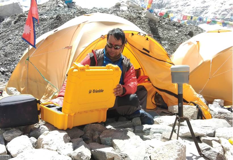
Trimble provided gear for the summit as well as the geodetic network. Trimble India provided a NetR9 base receiver, two R10 GNSS rovers for the survey of the peak, DiNi digital levels, S9 total stations that were used to measure baselines for the reference network and TBC [Trimble Business Center] software for GNSS postprocessing.
A network of 298 survey marks was established around the area of the mountain with gravity measurements and GNSS on each. DiNi digital levels and trigonometric levelling with total stations was used to establish precise elevations on a subset of these marks to serve as primary points. GNSS observations were carried out on each for horizontal positions.
Eight temporary continuous operating reference station (CORS) receivers were set up on and around the mountain at elevations between 16,000-20,000ft – several by helicopter. This campaign was long static sessions, constraining to the national CORS network. Nepal’s CORS network was built in cooperation with the international scientific community to study the plate tectonics of the region. This largescale geodetic undertaking was phased over multiple years at an estimated final cost of nearly US$1.3m.
The Chinese team also set up a CORS network using a mix of multiple manufacturers’ gear. It was reported that several different Chinese rovers were carried to the top, though only one has been confirmed by name (a P5 from CHC Navigation). One of the few photos released by China shows a GNSS antenna on a rod, along with what appears to be an array of prisms (and a lot of flagging for visibility from afar). It is highly likely that laser measurements were also employed.
Both teams collected just under two hours each of GNSS observations, but with multiple constellations, providing robust post-processing results.
The Nepal team climb
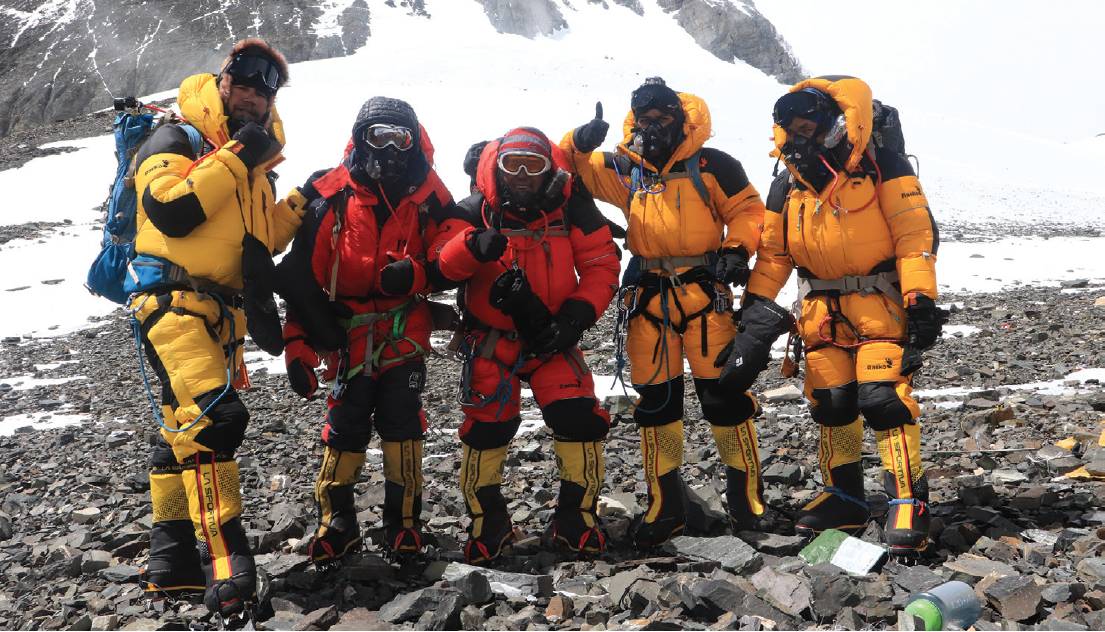
Chief survey officer Khim Lal Gautam, survey officer Rabin Karki, lead Sherpa Tshiring Jangbu and two additional Sherpas set off up the mountain, choosing the South Col route – the most popular route. It is the same route Sir Edmund Hillary and Tenzing Norgay took for the first ascent in 1953. This was Khim Lal Gautam’s second ascent, having been the principal of the Nepal Civil Servant First Mount Everest Expedition in 2011.
May is one of the best months to climb, making it also the most crowded time on the mountain; there can be backlogs of climbers near the summit. For this reason, Khim Lal Gautam chose to make the final push in the middle of the night, so they could have the small summit area to themselves to do the GNSS and GPR measurements. Khim Lal Gautam recorded:
“By the morning of 21 May, we were able to arrange for the required additional oxygen at the South Col, with the help of other Sherpas. At around 2pm the same day, I decided to start our final journey from South Col to the summit. I knew it usually took climbers 10 to 15 hours to reach the peak of Mount Everest from South Col depending on the strength of the climbers. When we summited Everest at 3:00am, initially there were no other climbers. The first climbers we met were two Polish climbers. About halfway through our GNSS measurement, we witnessed a large crowd of climbers approaching.”
The impending crowd and the harsh conditions meant for a narrow window for measurements.
Measurements
One of the two Trimble R10s was set up on a mini-tripod with a quick-release attachment. The tripod was specially designed by Khim Lal Gautam to work on Everest. It is lightweight and short, allowing for greater stability in the wind. It had a locally designed special type of metal screw, one foot long, enabling it to be fixed in the packed snow at the summit.
Working on the top of Everest is a challenging task; the conditions were rough throughout, but thankfully, the conditions did not deteriorate further during their work. The direction of the strong winds was random, so to further stabilise the tripod the team took turns laying down on the snow to hold it.
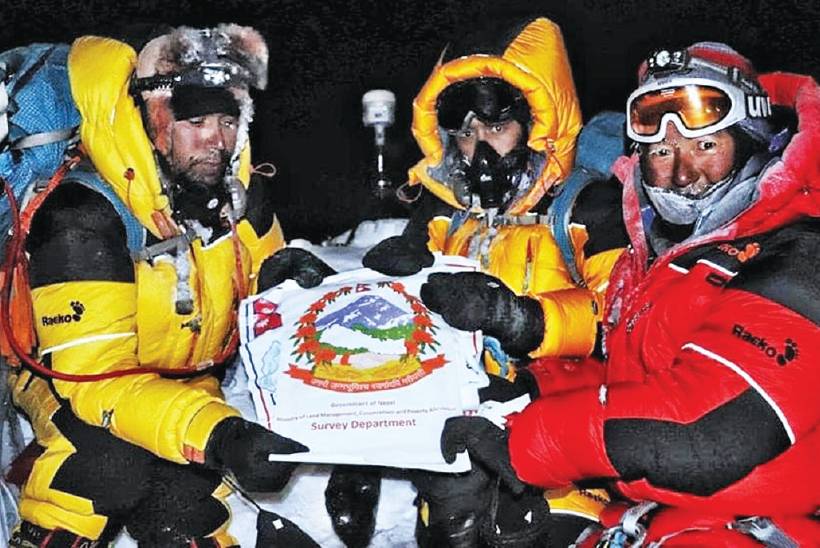
The R10 had been pre-configured to begin recording static observations on power-up, as removing heavy gloves to operate a controller keyboard could be dangerous. Unfortunately, lighter gloves were required to operate the data controller of the GPR receiver, which contributed to the frostbite that some of the team experienced. The area of the summit is about 5-6m from side to side. While the R10 GNSS was collecting data, GPR observations were performed to determine the depth of the snow and ice on the summit at that time. The GPR was a Geophysical Survey Systems (GSSI) SIR 4000, provided by the US National Geographic Society. The team scanned the surface around the top, an area of about 50-70 square feet, for about 10 minutes.
After having worked for about two hours, the crowds of climbers approaching the summit increased and it was difficult to deter them from coming near the working area, and as they had limited supply of oxygen, the team decided to descend. In many ways, the decent can be the most dangerous part of the climb; the climbers are exhausted from a long day in the ‘death zone’ above 24,600ft. Up until that point the team had fared quite well, apart from fatigue, numbness, and some cyanosis (a level of frostbite). But Khim Lal Gautam was about to face personal peril, he recalls:
“I became unconscious at the altitude of around 27,000 feet and lay down on the blue ice near the South Col. I stayed unconscious for about two hours and only woke up after an unknown climber kicked me from behind – maybe he thought I was already dead. After I woke up, I found myself alone. As we were on the descent and near the camp, Tshiring possibly concluded that as we were in a less risky area, I was simply lagging behind and would come to the South Col eventually by myself. This long unconsciousness cost me part of the tip of my left toe forever, due to frostbite. Normally, when a climber loses consciousness and assistance is not timely, it is difficult to wake up again. Luckily, I woke up. I feel this was the miracle of my life.”
Due to weather conditions, the surveyors and Sherpas would spend a total of three nights above the death zone – usually climbers spend only one. But without further incident, they returned safely.
Joint announcement
On 8 December 2020, a live virtual announcement event was held. Representatives from Nepal and China simultaneously tapped keys and the new elevation appeared on the shared screen: 8,848.86m (29,031.69ft). It had been over 18 months since the Nepal survey, and more than six months since the Chinese survey. And while there were certainly technical details to work out between the two teams, like geodetic references, much of the delay was likely due to planning the details and messaging for the joint announcement.
The hard-working teams had to survey in harsh conditions. Much of the fieldwork for the regional geodetic survey was also at high altitudes and in inclement weather. The project was a matter of national pride for Nepal and a prestigious undertaking for the Nepalese government.
Khim Lal Gautam is honoured to have been entrusted with leading the summit team and overseeing the survey. Indeed, it was his experience, commitment to the mission and ability to act decisively that brought about the success of the Nepal survey. He says this expedition is a testament to the skill, tenacity and honour of surveyors worldwide.
Jodie Hartnell, Trimble
www.trimble.com www.geospatial.trimble.com @TrimbleNews
Thanks to Susheel Dangol, Coordinator and Chief Survey Officer, Sagarmatha Height Measurement Secretariat.