Preservation of industrial architecture at Horgan’s Quay Cork
Simon Hall, Content Marketing Executive, Leica Geosystems part of Hexagon, with Juraj Knotek, Digital Construction Specialist, BAM Construction

HORGAN’S Quay is a major rejuvenation scheme for the City of Cork. The six-acre mixed-use comprises of a new scheme of contemporary offices, homes, hotel, leisure facilities, shops and restaurants.
The restoration of the on-site heritage buildings such as the goods shed, carriage shed and original station house make the centre pieces of this mixed-use development.
All the new structures have been designed with phased development if required. A vital goal of the project was centred around the conservation of the site’s Industrial heritage, which spans back over 160 years to the original Penrose Quay railyards used by Irish Rail.
In 2016, BAM Ireland, as part of a joint venture with Clarendon Developments, were awarded the contract to survey and capture the pre-existing structures of the station house, carriage house and other existing infrastructure. This itself was a pivotal step in preserving the heritage of the site throughout the construction.
Challenges
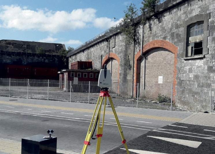
The increasing demand for 3D reality capture in building construction companies in the last few years has seen many contractors move away from traditional surveying methods. In many cases, there is a requirement for 3D surveying and verification of as-built structures, allowing design teams to create increasingly accurate Building Information Modelling (BIM) models.
Knowledge and understanding of laser scanning technologies are very important for site engineers and project managers.
Accurate and correct surveying of these existing building structures on site was vital, as many of them were incorporated into the new designs of the site.The carriage shed, goods shed, adjoining office building and station house are fine examples of the industrial architecture of Cork that will be preserved in future developments of the site.
Sadly, over time, many of these structures have fallen into disrepair and dereliction.
Accurate and correct surveying of these existing building structures on site was vital, as many of them of them were incorporated into the new designs of the site, such as the carriage shed on the north part of site being incorporated into the new hotel, the office building and part of the goods shed as the entrance to the new office block, and the station house forming part of the residential development.
The surveying of the existing roof trusses and all supporting elements was also very important. Laser scanning technique was the only way to accurately capture position of all these elements on site.
Technology
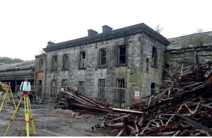
In 2015, BAM Ireland were looking to implement laser scanning technology which could be used for a variety of different tasks. The solution they required was for a scanner with high quality, reliable data and which was suitable for building sites.
The increasing demand for 3D reality capture in building construction companies in last few years has seen many contractors move away from traditional surveying methods. In many cases, there is a requirement for 3D surveying and verification of as-built structures, allowing design teams to create increasingly accurate BIM models.After research, BAM Ireland made the decision to implement the Leica ScanStation P40, the high-definition 3D laser scanning solution, which has been in use on the project site since 2018.
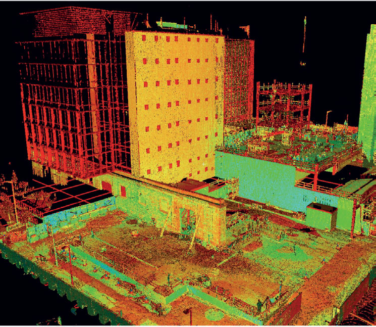
The P40 was used to capture 3D geometry of the existing site infrastructure, creating an as-built representation of the site, allowing the BAM Ireland team to generate 3D data for integration into BIM.
Users on-site were able to automatically capture, register and examine scan and image data.
The P40 delivers 3D data and high-dynamic-range (HDR) imaging at a scan rate of 1 million points per second at ranges of up to 270m.
Range and angular accuracy paired with low range noise and survey-grade dual-axis compensation form the foundation for 3D colour point clouds mapped in realistic clarity.
It was vital to capture as-built structure and due to size and complexity of some building structures, they could only be surveyed with laser scanning. The P40 allowed us to do this in almost every kind of weather.
This is very important for building construction companies where in some cases there might be only a short window of opportunity to survey area of interest.
Implementation
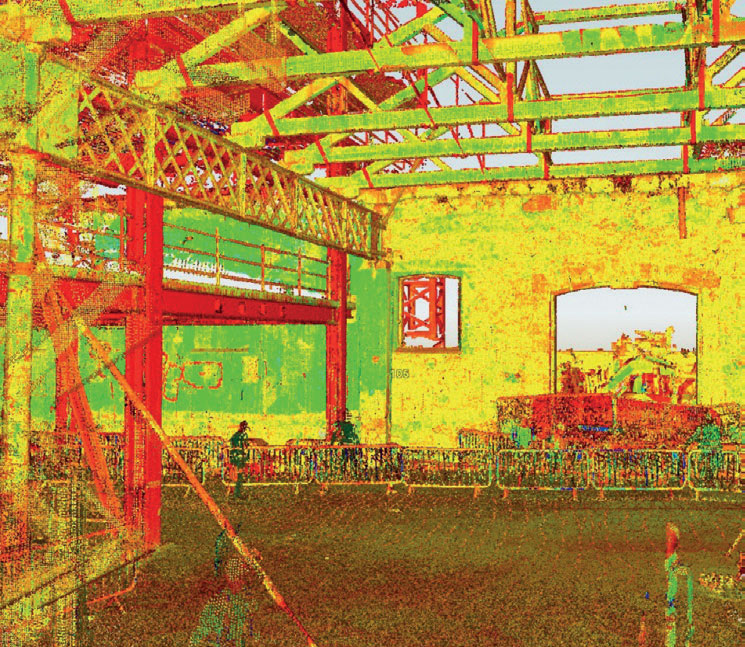
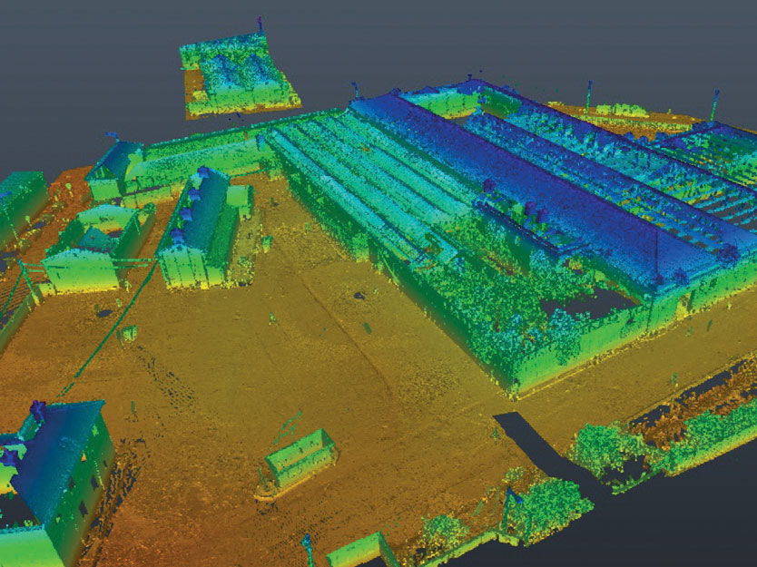
The whole site, surrounding areas and all existing structures were surveyed before BAM moved to the site to commence the construction phase of the project.
It was vital to capture as-built structure in high quality and high resolution, and due to size and complexity of some building structures, they can only be surveyed with laser scanning.
These surveys produced the valuable data sets which aided BAM Ireland to set out site facilities and plan site enabling works, such as the positioning of towers cranes.
This was a vital component of the project as the site was incredibly busy, surrounded by the new railway station as well as another building project nearby.
A crucial point was the surveying of existing building structure which were to be incorporated into the new designs.
The 3D information was beneficial for the design team as the existing 2D drawings of the site were not sufficient.
It was also important to capture some parts of building in-situ, including existing roof trusses and supporting columns and beams, which are now part of the new office block.
We used the laser scan data during the whole lifespan of the project. It was important to do initial 3D survey of whole site to provide design team with high accurate information about the structures on site and their condition.
Benefits
For a project of this size, scale and historical importance, it would have been nearly impossible to complete all the required surveying without the use of laser scanning techniques. The planning and design for joining of existing and new infrastructure could only be accomplished using this technology.
Construction activities in this area were a great opportunity for archaeologists to explore some parts of former railway station infrastructure, which had been covered by concrete for nearly half a century.
Construction activities in this area were a great opportunity for archaeologists to explore some parts of former railway station infrastructure, which had been covered by concrete for nearly half a century.During excavation works, the team from BAM exposed several of the original turning tables. Thanks to the laser scanning technology, these structures were also captured, allowing 3D drawings of all the excavated structures to be prepared.
Roof trusses were also removed and restored outside of building site, and later reinstalled in the same positions. The team at Leica Geosystems provided technical support to BAM Ireland throughout the project timeline, helping to provide solutions to issues with software and hardware.
This support extended to other projects using the Leica RTC360 3D laser scanner, used on trial across several BAM sites.
Using the laser scanning helped the design team to create design models with minimal clashes with existing structure.
The scan data was shared with the design teams to provide the most up-to-date information about building. BAM Ireland used the scan data several times to verify design drawings and to avoid any potential problems on site during the construction phase.
A view to the future
BAM Ireland is planning to continue using the P40 in most of its projects as part of the verification process of as-built or existing structures. It has also successfully tested the combination of P40 and Leica BLK360 scanners and their data for utility surveying.
3D Reality capture is now fully integrated into the workflow. Certain parts of the project we would not have been able to finish without 3D point cloud survey. This project was also used as a test base for Leica RTC360 scanner and Leica BLK360 imagining scanner.
Simon Hall, Content Marketing Executive, Leica Geosystems part of Hexagon, with Juraj Knotek, Digital Construction Specialist, BAM Construction
simon.hall@hexagon.com www.hexagon.com