A truly creative approach
Lucy Hamilton, KOREC Group
IN a recent article in Civil Engineering Surveyor, CICES president, Andy Evans considered two interesting concepts, the uncertainty of success and the notion of risk, including financial risk, when it comes to the adoption and investment of new and innovative technologies on projects. Whilst he was predominantly referring to construction projects, it’s also an interesting point of view when applied to the take up of technology and untried methodologies within the survey industry.
Progressive mindset
While some companies are happy to deliver tried and tested results using existing instruments and methods, there are also businesses that are gaining a more competitive advantage through a wholly enterprising approach.
A recent project undertaken for Dorset Council on the Weymouth seafront by Brunel Surveys is one example of how fine-tuning a client’s approach to a job ensured its delivery gave the best results using the right solutions, including through the adoption of new technology and methodologies, to achieve it.
Weymouth Harbour site challenges
The council is currently undertaking investigations and research towards a business plan for the Weymouth harbour and seafront area. It will identify future construction and building projects, which will increase the area’s flood resilience and protect properties.
Working closely with the client, the survey manager, combined data from a boat and trolley-mounted mobile mapping system with GNSS positions and scan data to create a survey.Following a tender process, Brunel Surveys was contracted to undertake a topographical survey of the beach, the harbour, a nearby nature reserve and the harbour wall. The wall needed to be surveyed from both sides and the client originally requested a point cloud generated by static 3D scans for this aspect of the work. However, the site presented a number of challenges that needed to be analysed before presenting a solution.
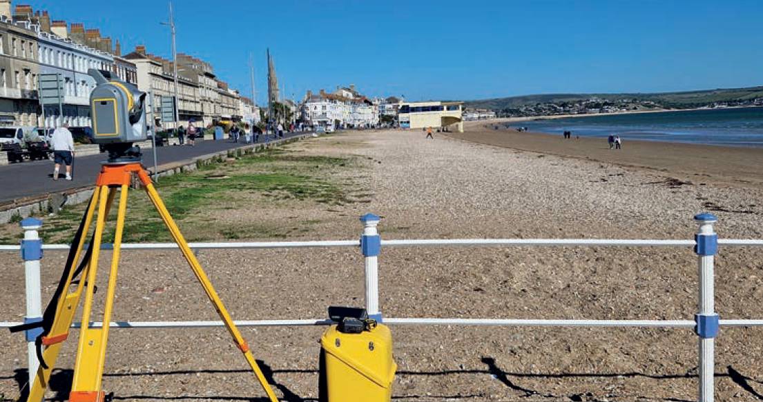
The topographical survey of the harbour and nature reserve would be fixed to the National Grid using centimetre-accurate GNSS equipment.
However, a point cloud generated by a 3D laser scanner cannot be scaled accordingly. If static scans were used for the harbour wall, although the precision would be good, the scale factor would have been an issue with a mismatch of around 400mm over 1km. Although a large job, all the site work would also need to be completed within a two-week time period.
Other challenges include the fact that Weymouth Harbour is a busy area with scooters, pedestrians, traffic and high buildings which would dictate how the area could be surveyed safely and accurately. Even scanning from the other side of the wall would be problematic due to boat traffic. It was additionally important to capture as much detail as possible of the 2km long harbour wall from both sides, despite the boats.
Harbour wall survey
Although using a 3D laser scanner (requested by Dorset Council) would provide the high level of detail required, this gain was offset by other problems. Namely that the point cloud could not be scaled to fit the topo survey and overall accuracy would be lost using stitched scans. Additionally, the level of boat traffic and the amount of time the scanning would take would also be problematic.
Weymouth Harbour is a busy area with scooters, pedestrians, traffic and high buildings which would dictate how the area could be surveyed safely and accurately.
Other solutions were therefore investigated, including simultaneous localisation and mapping (SLAM) technology used on previous boat surveys and static scanning from a boat neither of which were feasible for this job.
Mobile mapping was selected as a result of this research. Although it might not have the same accuracy as the 3D scans, the level of detail collected would be acceptable and there would be a far bigger risk of using a point cloud that couldn’t be scaled and consequently having a mismatch with the topo survey than in using the mobile mapping system.
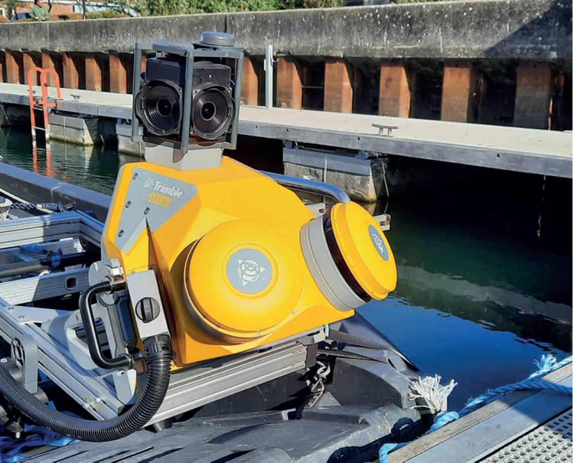
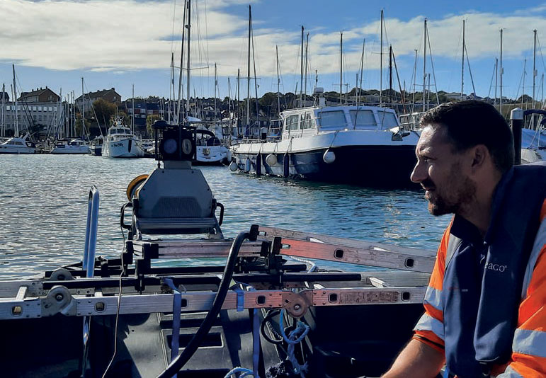
Working with KOREC, it was agreed that a Trimble MX50 system would be mounted on a boat for one side of the wall to be mapped from the sea and then mounted on a trolley to map the other side. A quad bike had to be dismissed due to the number of pedestrians in the harbour area, therefore a special trolley was constructed and tested and a local captain commissioned for the boat survey.
On the day of the survey, the MX50 was mounted onto the boat and operated on-board via a mobile phone app. The boat was carefully navigated along the shallow water and the data collected. The system was then mounted on to the customised trolley and further data collected shoreside.
The topographical survey of the harbour and nature reserve would be fixed to the National Grid using centimetre accurate GNSS equipment
The entire survey of the wall took just one day.
Topographical survey
This was an extensive survey that included many different aspects including a nature reserve, the harbour, beach and also footpath levels. While the Trimble S6 total station could be used in quieter areas, the need to avoid pedestrians and dogs meant that having tripods around the area would not be workable. The solution was therefore to set up a single base station in a safe place and use two Trimble R12i GNSS rovers.
Although the data generated would not be as precise as total station data, the overall accuracy would be good and could be verified by also using a Trimble SX10 total station.
Although using a 3D laser scanner, as requested by Dorset Council, would provide the high level of detail required, this gain was offset by other problems. Namely that the point cloud could not be scaled to fit the topo survey and overall accuracy would be lost using stitched scans.At each control station the SX10 was used to carry out a small scan to verify the accuracy of the GNSS data. If there were buildings in close proximity which might compromise the GNSS signal, it was again used.
Using the rovers enabled the data to be captured fast due to tilt compensation technology during point measurement without the need to precisely level the pole.
New methodology – was it worth it?
The processed data automatically selected the centre of each of the targets that were scanned, assigning coordinates.
This enabled the topo and mobile mapping data to be matched and combined into a single data for the client. The job was completed on time with just two weeks on site and two weeks in the office.
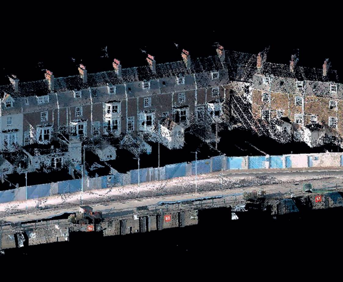
The colourised mobile mapping data was checked frequently and found to deviate no more than 25mm from the topo survey.
Careful planning, past experience and by checking each element carefully, mitigated any risk associated with new methodology and it was a job well done.
Lucy Hamilton, KOREC Group