Engineering geophysics
Sam Brook, Infrastructure Geophysics Manager (UK), Fugro
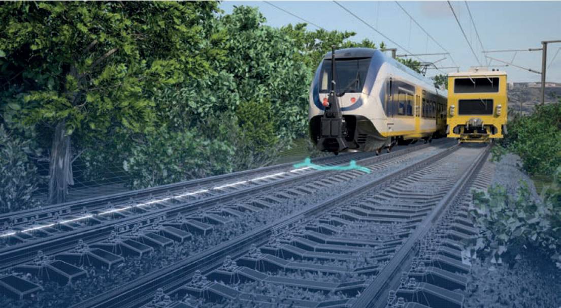
Railway inspection using mobile mapping system.
WHEN developing assets or infrastructure, early and thorough preparation is vital to avoid delays and increased costs. One of the biggest contributors to operational risk in the built environment is uncertainty in the condition and structure of common materials like concrete, asphalt and ballast and the key to effective preparation is to properly deal with this uncertainty.
Engineering geophysics is a crucial step in risk management and can deliver multiple benefits across a variety of asset types, such as road, rail, infrastructure, foundations, tunnels and utilities. In characterising a development site, geophysical screening can identify where potential ground problems lie before committing to costly and labour-intensive intrusive investigations which, in turn, can lead to unwanted disruption to asset owners and users.
With an effective geophysical toolkit at their disposal, specialist service providers can apply the latest technology, expertise and different geophysical methods in a wide range of market sectors and environments. Enhanced by georeferenced digital models (digital twins or building information modelling (BIM) models) that provide a single point of reference for a project, the specialist advice they provide can support the management and maintenance of networks and assets and deliver significant savings in cost and time.
Survey to identify hidden voids.
Minimising disruption to road and rail services
Intrusive investigations can cause major network disruption but the consequences of asset failure are inevitably far more serious. A recent landslip on an Oxfordshire railway led to a highly disruptive 11-day line closure, an event that might have been avoided with a thorough understanding of both the construction and the subsurface environment.
An effective geophysical toolkit will often contain ground penetrating radar (GPR), an accurate and non-destructive method that identifies below-surface changes in electrical properties by using high-frequency radio waves. This proven technology enables rapid assessment of the construction and condition of a road or railway, unlocking insight into variability over large networks. Repeat (timelapse) surveys can readily identify changes so that action can be taken before more serious problems develop.
The effectiveness of GPR has been further enhanced with recent developments in machine learning algorithms, enabling rapid, early interpretation of data. Implementing these algorithms during recent projects in Denmark and Australia, Fugro reported significant time savings in data analysis (and negligible detriment to the robustness of data interpretation). This new approach quickly identifies significant changes in data that may previously have been missed in large datasets.
Eliminating or minimising the need for road closures or rail possessions reduces the impact of survey investigations, limiting disruption, helping to manage costs and reducing health and safety risk exposure. The use of traffic- and line-speed data collection, such as GPR or deflection information, can also support the development of efficient maintenance schedules.
Fugro’s mobile mapping equipment collects survey data at traffic- and line-speed, enabling the assessment of large linear sections of roads or tracks with minimal disruption. Multiple types of data, historical and survey, such as point cloud data, are then combined into a single digital model from which intelligent decisions can be made.
Locations that are identified as requiring further detailed non-intrusive investigation may require ‘boots on ballast’ methods but these surveys can be completed during short possessions, often overnight when there are fewer movements. Methods such as electrical resistivity tomography or multichannel analysis of surface waves (MASW) on the railway, for example, can quickly highlight areas of sub-track weakness that have the potential to migrate, causing a more serious issue.
Understanding the construction secrets of buildings and coastal structures
Fast and accurate investigation within the built environment is just as important. Where buildings or structures have been in situ for many years, often with multiple occupiers and varied uses, a full understanding of their construction is crucial for future development or to extend their design life. Historic changes are often found to have not been recorded or records have been lost.
Fast and accurate investigation within the built environment is just as importantInformation on the precise location of hidden obstructions, such as reinforcement or chimney flues, is vital if a proposed development is to proceed. The discovery of an unknown feature has the potential to delay a project by weeks, increasing costs and necessitating costly workarounds or new designs. Crucially if this information can be gathered rapidly, with light-touch, nondestructive equipment the disruption to building owners and users is minimal.
As with roads and railways, the use of GPR enables large areas to be investigated rapidly and, if necessary, information can be provided on site in real-time. GPR technology has become widespread with the development of smaller, portable, high-frequency systems, especially as they often don‘t require data to be interpreted by a specialist geophysicist. But when a structure is not as expected, or where a more detailed investigation is needed, the experience and knowledge of an expert in geophysics is essential.
Climate change is having an increasing effect on infrastructure. The increased frequency and impact of significant weather events is driving attention to coastal defences and the protection of infrastructure that is situated in areas that have become hazardous. Centuries-old coastal defences are in need of reassessment for improvements, or even to determine if these structures have come to the end of their design life and require replacement.
Large stretches of coastal defences can be surveyed using GPR or other non-destructive techniques such as half-cell potential and resistivity. For earth embankments, non-intrusive investigation methods such as MASW, resistivity and conductivity profiling are valuable components of a survey programme. The resulting geodata can help target areas of concern or weakness and trigger repair works before any visible signs of collapse.
Critical geotechnical parameters for foundation design
Ground investigations are an essential first step in both new developments and redevelopments but they are time-consuming and costly. Geophysical techniques such as electromagnetic conductivity (or magnetics) can quickly identify the presence and location of buried obstructions within the top two to five metres of the ground surface at previously developed sites. The geodata can help direct intrusive work away from obstructions or inform decisions about the removal of old foundations or even their re-use.
At new-build sites, engineering geophysics can produce information on the elastic properties of materials and geological features below the ground, using seismic or resistivity techniques. Innovative, light-footprint passive seismic techniques, can be used to map, in 3D, subsurface variability and provide critical geotechnical parameters for foundation design.
Tunnel inspection and the changing human role
Tunnels make up the foundations of numerous modern towns, cities and communities but their inaccessibility can present difficulties when it comes to inspections. While space restrictions also determine the kind of inspection work that can (and cannot) be performed, the geophysical toolkit can produce the required geodata, including information on the construction of the tunnel lining and hidden shafts.
Investing in engineering geophysics at the beginning of a project leads to reliable characterisation of the subsurface, thereby reducing uncertainty.GPR is widely regarded as a preferred method for tunnel inspection, collecting data in a safe and efficient manner at speed from the ground (although it requires a rail possession or road traffic management). Other methods include thermography, a valuable assessment tool that identifies changes in temperatures of the surfaces – an indicator of change. Thermography is conducted from an in-tunnel vehicle, and so provides a rapid assessment with little impact on the tunnel or its users.
The human role in tunnel inspections is changing as technology replaces visual inspections. New automated systems, using laser scanners and imagery, repeat surveys at regular intervals and can identify changes rapidly. With the automation of routine inspections, inspectors can focus their expertise on detailed investigations.
Mapping underground utilities
Before breaking ground at a construction or development site, surveys should detect the presence of underground utilities, whether they be active, abandoned or redundant. These surveys may typically utilise GPR or cable tracing techniques and they adhere to the British Standards Institution specification, PAS 128:2022 standard, acquiring data that will help to avoid utility strikes. This well-known standard specifies requirements for the detection, verification and location of underground utilities and provides a way of accurately mapping underground utility networks.
On-site mark-up of the survey results is quick and efficient and can ensure the progress of projects but investing in a modest amount of additional processing and interpretation can significantly the reduce risks associated with breaking ground. Offsite interpretation of survey data by experienced geophysicists can provide detailed, robust and timely information.
Early phase geodata for greater certainty
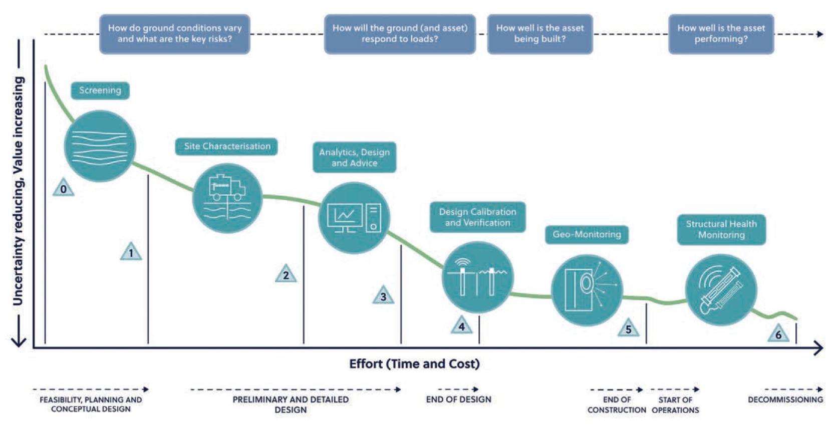
Fugro’s Geo-Risk Management Framework provides a means to visualise how data can be leveraged throughout the lifecycle of a construction project from conception through to design, operation and decommissioning to reduce uncertainty. Investing in a geophysical investigation as a screening tool at a very early stage can set the project on the right trajectory to develop a robust understanding of the subsurface and thereby reduce future uncertainty and risk.
But geophysics also has a key role to play in each of the lifecycle stages from optimising site characterisation programmes to construction quality control and to understanding structural health and ultimately extending the working life of critical infrastructure assets.
Sam Brook, Infrastructure Geophysics Manager (UK), Fugro
Image credit: Fugro