FROM COMPLEXITY TO CLARITY
Tackling an expanding brief using cutting-edge technology
At any given time, Glanville Consultants oversees more than a thousand active projects, demonstrating its ability to deliver its services with precision and efficiency across the UK and Ireland. Committed to adding value and applying innovative thinking to all its projects, the company has recently launched a studio for the generation of 3D models using point cloud data. The output of this studio is particularly useful for visualisation during the planning and design stages of a project.
Scan data shown on the Trimble T10x tablet.
Much of the as-built data used in this 3D studio will be generated by the company’s Trimble X9 3D laser scanner, complementing Glanville’s comprehensive Trimble technology portfolio that also includes total stations and GNSS systems. This integrated suite of equipment allows the company’s surveyors to adapt workflows and equipment seamlessly, ensuring flexibility and efficiency, particularly on long-term or complex projects like the one that Glanville is currently undertaking in Oxford.
The initial topographic survey had been conducted by the company in 2018/19, which was followed by a request to update the survey and include the external elevations of the main building and all the buildings on the site, as well as a roof plan in 2D and 3D.
This project has required extensive laser scanning for an as-built survey on behalf of the Oxford Health NHS Foundation Trust and the University of Oxford. The Trimble workflows have been key in keeping the project efficient, allowing surveyors from Glanville’s regional offices to collaborate effectively as the project continues to evolve.
The Warneford hospital, the oldest in-patient unit in use across the NHS, no longer meets the needs of a modern mental health institution. Therefore, ambitious plans are underway to replace it with a new mental health hospital, a modern scientific facility for the world-leading brain research taking place at the University of Oxford and a new post-graduate college focused on medical sciences, bio-engineering and related disciplines.
Responsible for liaising with the architect and managing the work on this project, which is at the pre-planning phase, is Glanville senior surveyor, Lauren Whittaker, who took over the project during the hiatus between the initial topographic survey and the expanded plans that followed.
Additionally, of the 34 buildings on the site, many were listed requiring more detailed scans to aid the planning application.
The initial topographic survey had been conducted by the company in 2018/19, which was followed by a request to update the survey and include the external elevations of the main building and all the buildings on the site, as well as a roof plan in 2D and 3D. Additionally, of the 34 buildings on the site, many were listed requiring more detailed scans to aid the planning application.
While initial topographic survey work had been undertaken using Trimble robotic total stations and GNSS, some scan work had already been completed before Glanville took possession of a new Trimble X9 3D laser scanner. The X9 was then used to complete the external work and internal scans where required.


A combination of 2D elevation information, scan data and 3D visualisations.
One of the primary challenges was the complex nature of the project itself. It involved multiple surveys conducted by different Glanville survey teams over an extended period, all across a large site.
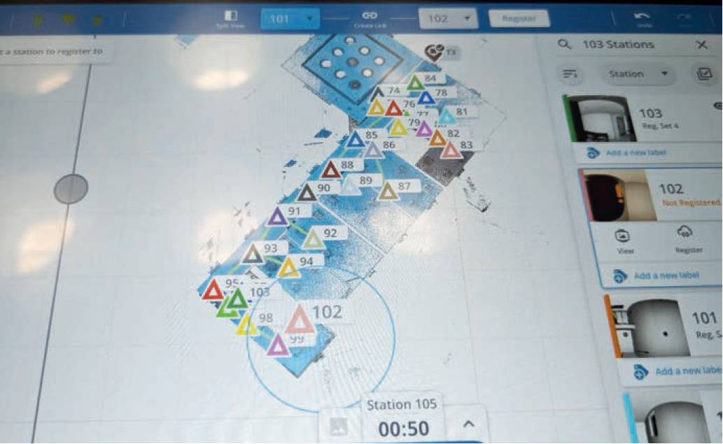
A meticulous phased approach to the work ensured nothing was missed and everything would fit the original control network. Checkerboards were placed around the site and captured as a precision point using the X9’s laser pointer, and each one given a name. Back in the office, the traverse is processed and control can be applied to the scans within the Trimble Perspective software via the georeferencing tool.
During the scan work on-site, the X9 was used for both internal and external surveys, with the team opting for 52 second, two minute or four minute scans depending on the level of detail required in relation to their intricacy. The X9’s on-site registration was one of the many features key to the success of the project. It’s self-levelling also cut time by allowing the surveyor to move swiftly in and out of clinics with minimal disruption.
The captured data was then turned into a 3D model and 2D outputs for those involved in the project.
The 3D model is delivered to the design team via a Revit model and online viewer to make it available for all involved
The captured data was then turned into a 3D model and 2D outputs for those involved in the project. The 3D model is delivered to the design team via a Revit model and online viewer to make it available for all involved.