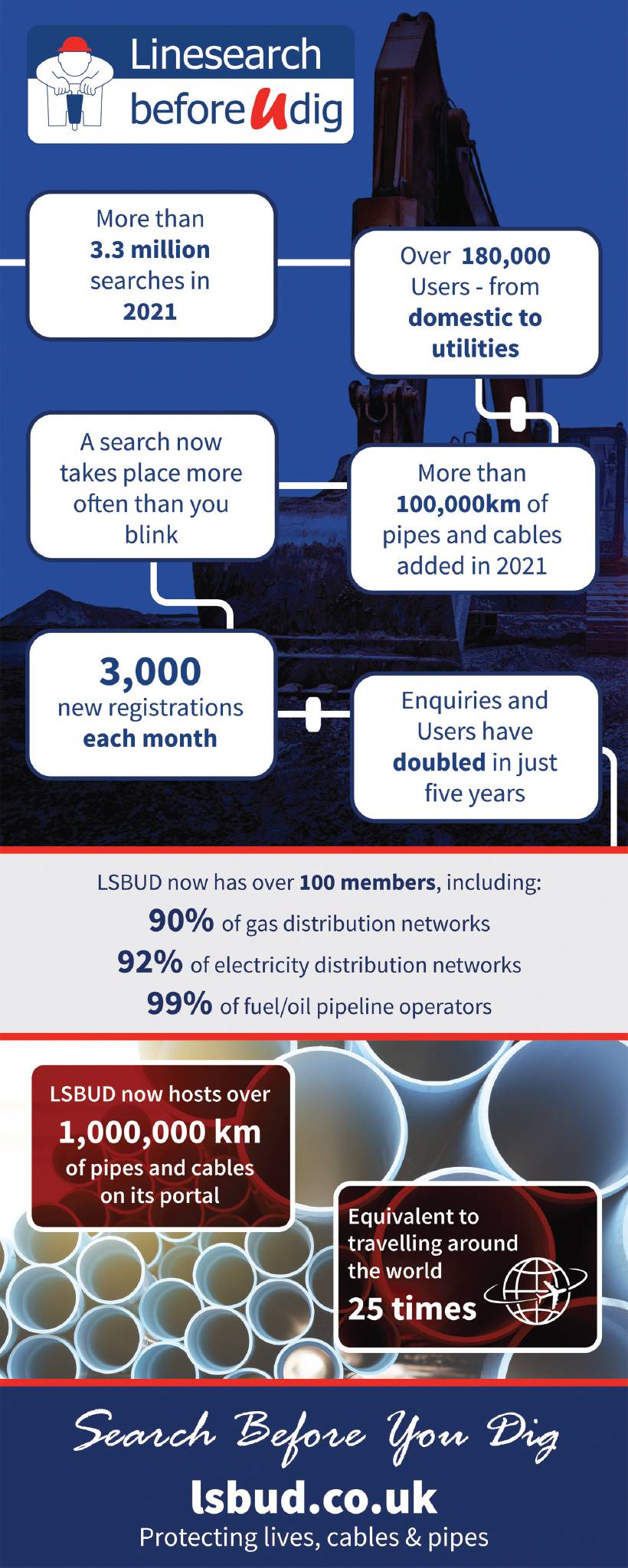
Education for the future
Dr Audrey Martin, Senior Lecturer, Technological University Dublin, talks to John Kerrigan FCInstCES, Ireland Country Manager, Leica Geosystems
THERE’S a distinct lack of awareness of what surveying is and just how significant it is to building and infrastructure projects, conservation and much more. Similarly, young people are often unaware of the opportunities within surveying. It’s because of this that both Dr Audrey Martin, senior lecturer at Technological University Dublin and myself are driven to bring more young people on board. In our conversation, we discussed Dr Martin’s journey from student to senior lecturer, the importance of education within the industry, and how technology has and will continue to evolve the nature of surveying.
How did you get from surveying student to senior lecturer at TU Dublin?
Despite my strength in numeracy and a keen interest in geography and maps, I didn’t always know I wanted to go into the industry. Originally I leant towards business and German, but my older brother inspired me to go into surveying. Seeing him spending his time in the attic bedroom drawing maps by hand and blaring music led me to decide that’s the type of course I want to do! My brother advised me that it wasn’t for me, which only spurred me on further!
My first project post-university was on site at a gold discovery in Croagh Patrick in County Mayo, west Ireland, where I surveyed the holy mountain. I then went on to work as a site engineer in Frankfurt, Germany. After a year of early mornings in freezing cold winters and scorching summers, I realised the job wasn’t for me. I then completed a survey-engineering degree through Oldenburg FH in Germany and went on to research my final thesis whilst part-time lecturing at TU Dublin.
It was during my time in Dublin that I realised how much I enjoyed the combination of research and working with younger people. I really like the educational side because I can continue my own research, stay on top of new developments, and work with young and enthusiastic people every day – which is a real privilege.
We met over 20 years ago when I was one of your students, geospatial technology has changed immensely since then, how do manage the pace of change?
The geospatial industry would be what is considered a disruptor technology, and we are at the forefront of that curve. The whole idea of moving from single-point data collection to point clouds having millions of points to analyse, as well as the resurgence of photogrammetry and the advancement of technology like drones and scanners are all new areas that we have to teach. But the fundamentals of the course are still the exact same – chasing the precision and the accuracy of a survey throughout.
Surveyors are now doing jobs that wouldn’t have even been considered 20 years ago, what’s the next role we’ll see developing?
The biggest roles that will develop are in geospatial data management. Data management will become increasingly crucial. Whether it’s data for GIS, BIM, planning or analytics – all of that has to come from somewhere. In anticipation of this change, our course is training students in the necessary skills to manipulate, format and present data in ways others can read and understand.
How do you inspire the next generation of surveyors in Ireland
The people who choose to join the course tend to be of three categories; some like the idea of working outdoors and not being stuck in an office every day; others have family in the industry; and the last group are those completing it part-time alongside their careers to progress into more senior roles.
Unfortunately, there are still large groups of people who would love a career in surveying but aren’t aware it exists. This is leading to a drop in the number of graduates, which is already being felt by businesses relying on the industry. Part of my role is to find the right pitch for the course and work out how to market it to the right types of people. In order to meet the needs of the industry in terms of the number of graduates turned out each year, new tactics are required.
I realised that instead of visiting schools myself, school pupils would rather hear from students directly. This year we began a project with our final-year students to promote the programme. Each student creates a pitch aimed at secondary level students, with four teams competing against each other. The students are doing some really exciting things. We’ve got video footage of survey equipment, questionnaires with existing students, TikTok videos and Instagram posts.
Where do students end up after they leave you?
The vast majority of students remain in the industry, working in geospatial data collection.
Some examples include roles in large scale scanning and data management, construction leads, hydrographic surveying on oil rigs, GIS roles such as optimising waste management routes, and heritage mapping and conservation.
I believe geospatial surveying should be broken down into the three Ms; measurement, modelling and management. In the future, the management end will be the biggest priority for the industry.And of course, there are those who go into academia.
The degree is one that will bring you anywhere in the world because the technology and fundamentals are the same everywhere you go.
There is a great supportive network of people passionate about getting more people into the industry in Ireland, as many of them are graduates of the programme themselves.
Whether it’s getting hold of the necessary equipment for student research and projects, bringing in guest speakers, and getting graduates to sit on assessment panels, we’re incredibly lucky to have the support of those in the industry behind us.
What will the future look like for the modern surveyor?
As new technology is introduced to the industry, more processes are being done autonomously. Most software and hardware can be preprogrammed, robots are being more commonly used, UAS can be preprogrammed to fly wherever and tolerances can be set automatically. It’s the data management, manipulation and visualisation that will be the priority. However, these devices, processes and the collected data will always need to be controlled and verified.
It’s likely that in the future most surveyors may become geospatial data managers and even data collectors. I believe geospatial surveying should be broken down into the three Ms; measurement, modelling (GIS and BIM or anything within that digital framework) and management. In the future, the management end will be the biggest priority for the industry.
John Kerrigan FCInstCES, Ireland Country Manager, Leica Geosystems, was talking to Dr Audrey Martin, Senior Lecturer, Technological University Dublin
john.kerrigan@leica-geosystems.com
John Kerrigan is a committee member of CICES Ireland and Northern Ireland. TU Dublin’s BSc in geospatial surveying and MSc in geospatial engineering are accredited by CICES.