The Singapore 3D mapping programme
Aude Camus, Senior Solution Marketer, Bentley Systems, with Hui Ying Teo, Senior Principal Surveyor, Singapore Land Authority

THE world’s second-most densely populated and land-scarce nation of Singapore has seen significant development of vertical buildings and infrastructure to accommodate the lack of horizontal space, making effective use of land space paramount to the country’s development.
To optimise land resources and promote economic and social growth, Singapore Land Authority (SLA) initiated the first nationwide 3D mapping programme in 2012 to map the entire country with rapid data capture technologies.
SLA performed aerial and street mobile mapping and delivered the country’s first national 3D map of Singapore in 2014/2015.
The 3D map has been used by government agencies in their policy formulation, planning, operation, and risk management. However, as a dynamic country with rapid development and complex land use, the 2014/2015 snapshot is no longer adequate to support government and stakeholder needs.
In 2019, SLA initiated a second mapping project to detect the changes over time and update the original map with improved accuracy to reflect the country’s dynamic urban development. The scope of the work included performing cadastral surveys, managing and ensuring precise positioning of national infrastructure and creating a current national 3D digital map.
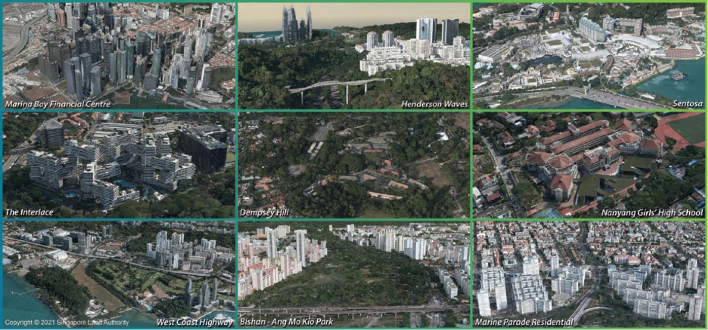
The project required aerial mapping of the entire country, and mobile street mapping of all public roads in Singapore. In addition to capturing the data and generating the updated map, SLA set an objective of ‘capture once, use by many’ to maximise accessibility to the map, making it available as an open-source 3D national map for projects among government agencies, authorities, and consultants.
Data processing, interoperability, security, and sustainability
In 2019, SLA initiated a second mapping programme to detect changes since 2012 improve accuracy to reflect the country’s dynamic urban development. Image courtesy of Singapore Land Authority.
As a large-scale, urban digital data capture and reality modelling initiative, the project presented survey and data processing challenges, compounded by data interoperability difficulties among the numerous agencies using varying legacy systems.
Furthermore, with national security paramount, the entire project had to be managed within a secure processing facility but then made available in a cloud-based environment to share with and support government agencies and infrastructure projects.
With a long-term sustainable vision, SLA sought to generate a reality mesh of the current existing conditions, integrating aerial imagery and point cloud data through local offline processing to deliver an accurate and reliable 3D map that could then be accessible through an open-source platform and continually updated over time.
As a government mapping agency, SLA continually faces challenges generating, managing, and sharing national large-scale datasets, which requires capital investment and maintenance of advanced IT infrastructure to accommodate mapping, modelling and collaborative workflows. SLA needed integrated reality modelling and mobile mapping technology to securely process the voluminous data from multiple sources into a sustainable nationwide dynamic, 3D digital twin, accessible in a controlled, cloud-based environment to the government and stakeholders.
Leveraging 3D reality modelling and mapping technologies
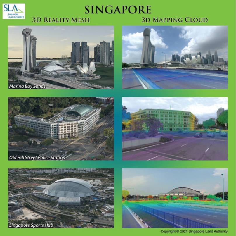
SLA captured more than 160,000 high resolution aerial images over a 41-day period and used ContextCapture to process them into a 0.1m accurate nationwide 3D reality mesh. Using Orbit 3DM to incorporate more than 25 terabytes of local street data, they integrated the point clouds into the model and, based on the model, generated a sustainable nationwide digital twin available via a secure, open-source platform.
The processing capability, interoperability and flexibility of Bentley applications facilitated the generation of the first country-scale 3D reality mesh and enabled SLA to successfully provide controlled access in a user-friendly format to serve different users and their requirements. The strength in interoperability enables the production of a 3D mesh, optimised for visualisation or analysis with 3D software, 3D GIS or web applications.
Using ContextCapture provided the flexibility to work locally or over the cloud, with multi-engine processing to efficiently process the huge amount of data. Integrating Orbit 3DM helped SLA establish a connected data environment that advanced national 3D reality mapping of Singapore, supporting a digital context and digital workflows among different agencies with access to a single accurate, reliable, and consistent data source. Orbit 3DM was the enabler to manage the large volume of point clouds and imagery, and bridge data sharing with other users with scalable cloud resources to support the long-term sustainable mapping programme that SLA envisions.
SLA delivered an accurate 3D reality mesh to achieve a breakthrough in national scale mapping that can be continually enhanced with 3D building and transportation models, machine learning and artificial intelligence, providing the framework for the development of a digital twin.
SLA captured more than 160,000 high-resolution aerial images over a 41-day period. Image courtesy of Singapore Land Authority.
Driving smart national development
Compared to traditional topographic surveys, the national aerial and street mobile mapping resulted in significant savings. SLA estimated a one-time cost of SGD $35m to map the whole nation via conventional methods, but using Bentley applications, it saved SGD $29m and generated the nationwide 3D reality mesh in just eight months, compared to two years using traditional methods.
Implementing the ‘capture once, use by many’ digitalisation strategy provides an annual potential savings for the government of at least SGD 13m based on a refresh cycle once every three years. Digital context, such as the nationwide reality mesh model, will give access of 3D information to agencies working on the same project and, at the same time, plan and review inputs from one another collectively. The open-source digital mapping solution facilitates new collaborative workflows and increases availability of national scale maps by 60%, enabling early planning within a shorter period of time at lower costs.
SLA’s national 3D mapping is an enabler for digital transformation and development of Singapore into a smart, resilient and sustainable nation. The reality mesh, complemented with building and transportation models’ attributes, will elevate the model’s intelligence as Singapore’s digital twin to support core 3D functions targeted at analytics, automation and visualisation.
The vision of the Singapore digital twin is a sustainable one with a robust mission to capture and update the city assets, unlock the unlimited intangible benefits of digitalisation, and drive smart national development.
Aude Camus, Senior Solution Marketer, Bentley Systems with Hui Ying Teo, Senior Principal Surveyor, Singapore Land Authority
www.linkedin.com/company/singapore-land-authority