Three UK utility providers are working with the National Digital Twin programme (NDTp) on a climate resilience demonstrator project. CReDo brings together Anglian Water, BT and UK Power Networks to develop a digital twin, with a specific focus on the impact of flooding caused by climate change on energy, water and telecoms networks.
The project will be delivered through a collaboration of research centres and industry partners including the universities of Cambridge, Edinburgh, Exeter, Newcastle and Warwick, the Hartree Centre, DAFNI, Science and Technology Facilities Council, CMCL Innovations, the Joint Centre for Excellence in Environmental Intelligence and Mott MacDonald. It is funded by UK Research and Innovation (UKRI), the Connected Places Catapult and the University of Cambridge.
Using the Information Management Framework (IMF) approach, which is being developed through the NDTp, CReDO will enable partners to share data across a secure platform and demonstrate the capability of the IMF approach to connect digital twins in a principled, scalable way to inform decision making in capital and operational planning. CReDo project lead Sarah Hayes commented: “We are really excited for what we can deliver through CReDo. Connected digital twins can enable increased climate resilience and collaboration across a team that spans industry, academia and government, and forms the pieces of the puzzle that unlock solutions to reaching net zero.”
A research consortium has formed a partnership with a local engineering company to introduce fibre optic monitoring technology to Sri Lanka. The universities of Moratuwa in Sri Lanka and Oxford are working with Access Engineering and the Cambridge Centre for Smart Infrastructure and Construction (CSIC) to introduce fibre optic monitoring technology for integrity testing of piles, axial shortening of multi-storey buildings, scour monitoring of bridges and damage detection of historic structures.
Dr Cedric Kechavarzi from CSIC described the fibre optic cables as acting like “a series of nerves to inform on the health and condition of infrastructure.” The project will be led by Dr Kasun Kariyawasam at the University of Moratuwa, under the guidance of Professor Malik Ranasinghe, Moratuwa’s former vice-chancellor, with financial support from Access Engineering.
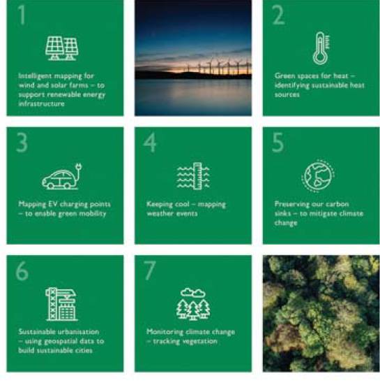
Ordnance Survey has published a set of seven sustainability innovation trends outlining ways in which the geospatial industry is working to combat climate change. The seven trends are:
- Intelligent mapping for wind and solar farms – using geospatial data to support renewable energy infrastructure.
- Green spaces for heat – using geospatial data to identify sustainable heat sources.
- Mapping EV charging points – using geospatial data to enable green mobility.
- Keeping cool – using geospatial data to map weather events.
- Preserving carbon sinks – using geospatial data to mitigate climate change.
- Sustainable urbanisation – using geospatial data to build sustainable cities.
- Monitoring climate change – using geospatial data to track vegetation health.
OS innovation lead Donna Lyndsay commented: “The trends we’ve identified are the key areas where OS believes accurate geospatial data can deliver innovative and actionable solutions to help tackle the climate crisis and ensure we continue to live sustainable lives. What we do individually is not going to solve climate change, there must be greater emphasis on data sharing and best practices on a global scale as it’s critical we act together and act now.”
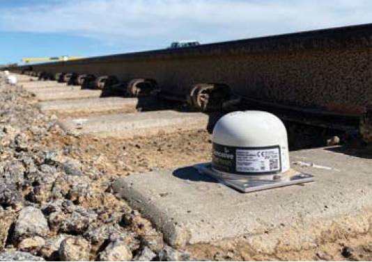
Senceive has launched a tilt meter that is ‘not much larger than a tennis ball’. The NanoMacro has a 12-15 year battery life and communicates across a radio mesh network. It can be used as part of an intelligent monitoring system that can respond almost instantly to an event such as a landslide by sending warnings and images to stakeholders. It has a fully enclosed radio aerial inside its IP69 rated enclosure – the highest ingress protection rating available. It is also the first Senceive device to include NFC (near field communication) compatibility, which enables users to adjust settings directly at the sensor.
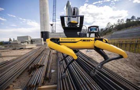
Trimble’s X7 3D laser scanner and FieldLink software are now fully integrated with Boston Dynamics’ Spot robot. The turnkey system, which was jointly developed with Boston Dynamics, takes advantage of the robot’s capabilities to navigate challenging, dynamic and potentially unsafe environments. The autonomous workflow for the laser scanner uses fully integrated Spot controls in the FieldLink software to create a predefined path of waypoints for Spot to follow and collect laser scans. The data can be tied to a jobsite project coordinate system, as well as individual scan stations.
Vismo is to supply its lone worker health and safety app to Ordnance Survey’s surveyors. The app provides employers with real-time locations of employees and has a red alert button for staff to use in an emergency situation.
- 40 of the world’s cement and concrete manufacturers have pledged to cut CO2 emissions by a further 25% by 2030. Members of the Global Cement and Concrete Association, including CEMEX, HeidelbergCement and Holcim, made the pledge ahead of COP26.
- Causeway Technologies has acquired the building products information platform SpecifiedBy.