
MODERN SOLUTIONS TO MODERN PROBLEMS
Addressing deforestation with drone mapping: a case study from Brazil
Technology is offering new hope in the fight to protect our planet’s biodiversity and secure a sustainable future.
One example is found within Brazil’s Atlantic Forest. This vast ecosystem in São Paulo stretches over roughly 3.46 million hectares, about 14% of the state’s land. It includes the Great Atlantic Forest Reserve, the largest continuous forest in the biome, spanning 50 municipalities across São Paulo, Paraná and Santa Catarina. Despite its immense ecological value, deforestation in São Paulo skyrocketed by 406% between 2019 and 2020, largely due to both regulated and unregulated real estate expansion and tourism.
The Atlantic Forest in São Paulo currently faces significant environmental pressure. This impacts the ecosystem, which supports species found only in this region. The forest also contributes to climate regulation, controls soil erosion and maintains water quality. To address this situation, methods such as drone mapping and photogrammetry are being applied to help protect this ecosystem.
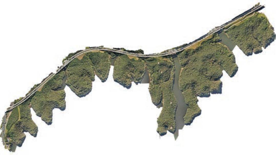
A high resolution orthomosaic provides a bird’s eye view of the park.
Drones utilised for the greater good
Brazil Flying Labs works with communities, using digital tools to address quality of life, promote sustainability and support diversity and gender equality in technology. Drones and orthomosaic maps are part of their work to preserve the Atlantic Forest, particularly within Águas da Billings State Park, supporting better management of this ecosystem. Drones capture aerial imagery, which provides a bird’s-eye view of the park. Park rangers then use this imagery to identify potential threats, including deforestation, poaching or unauthorised construction.
The orthomosaics represent the park’s terrain and are used for long-term monitoring and to detect changes within the area. The project’s primary objectives are to generate actionable insights from photogrammetric products such as orthomosaics, digital surface models (DSM) and point clouds; and to raise community awareness about the importance of forest preservation and the transformative role of drone technology in conservation efforts.
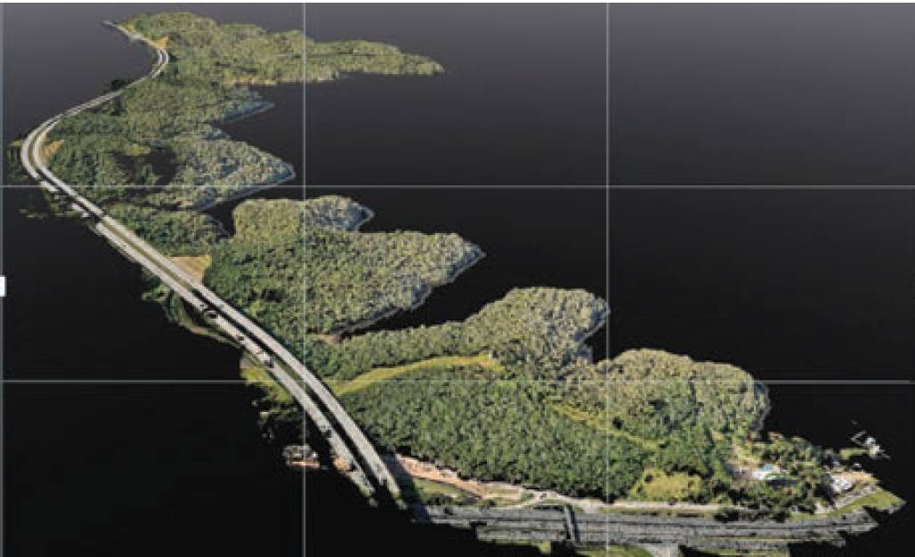
More than 1.8 billion georeferenced point clouds were generated for a detailed 3D topographic survey.
Creating high-precision orthomosaics and 3D models for conservation monitoring
The Brazil Flying Labs team executed drone flights over 180 hectares of the Águas da Billings State Park, capturing more than 2,800 RGB images with a 4.7 x 4.7 cm per pixel resolution and 70% overlap.
The Brazil Flying Labs team executed drone flights over 180 hectares of the Águas da Billings State Park, capturing more than 2,800 RGB images with a 4.7 x 4.7 cm per pixel resolution and 70% overlap. Flights were carefully planned over two days with a DJI Mavic 3T Enterprise, using only the RGB sensor for this project. Take-offs were from the SP-021 highway (Rodoanel Mário Covas), which marks the park’s boundary.
A digital surface model (DSM) was created, providing elevation data. This showed the park’s highest point at 861m above sea level, with the lowest point, at the dam’s water level, at 749m above sea level. The resulting point cloud contained over 1.8 billion geo-referenced points. This provided a 3D topographic survey to support conservation and monitoring efforts. The final report summarised the processing time for each stage.
3D mapping to advance AI algorithms and machine learning
The team is conducting visual inspections using the orthomosaic to assess forest conditions. They are also working on training an AI algorithm to detect exotic species, an essential step in protecting native biodiversity. To support this, images are being tagged for machine learning development. Beyond technical mapping, Flying Labs Brazil engaged with the community to raise awareness about conservation, with initiatives such as teaching high school students from the area about environmental education and drone applications in conservation.
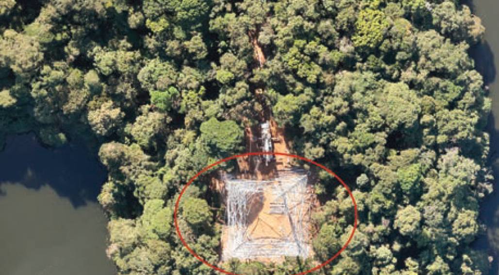
Detailed maps of the park allowed the team to identify structures and monitor the progress of infrastructure works.
Efficient drone mapping with Pix4Dmatic
The software was installed on both Mac and Windows systems, and it included automatic GPU detection. The team mapped an area of 187 hectares (1.87km2), capturing 2,800 images over four flights within two days. Both a point cloud and an orthomosaic were generated and the final report summarised processing times for each stage. The Fight for the Forest project highlights how mapping with drones and photogrammetry can support broader sustainability initiatives.
The Atlantic Forest regulates climate, protects water sources and supports biodiversity, with drone mapping and data analysis providing information for decision-makers, assisting conservation efforts to protect it.