Data Management
Byte-ing back better
Introducing a Q-FAIR approach to geospatial data improvement
AS I begin to write this, I am on a train hurtling 125mph through the British countryside. Through the wonders of data and technology, I can communicate with colleagues, check my location and estimate my time of arrival. This allows me to know how much writing time I have before arrival at my destination, and answer the crucial question of whether I have time for another coffee… I do.
This simple use of geospatial data helped me plan my day, but location data is used to support much wider decisions about our environment, our world. One of the most important questions decision-makers will always ask is; where?
The UK’s geospatial data and our geospatial capabilities are first class. We have long known the importance of location data to the public, as was aptly demonstrated in 1854 with cholera and John Snow’s famous water pump map. Today we have seen similar foundational techniques used to navigate the tricky geoscape of COVID-19, in conjunction with cutting edge technology, data analytics and expert practitioners.
The UK public sector holds and uses vast quantities of valuable geospatial data that shapes and improves our lives, in often unseen ways. The Geospatial Commission was set up to ensure that the UK realises the potential economic, social and environmental value of this data. The Geo6, our six partner bodies – British Geological Survey, Coal Authority, HM Land Registry, Ordnance Survey, UK Hydrographic Office and Valuation Office Agency – have location data at their core, and this allows them to innovate and plan for the future of that data.
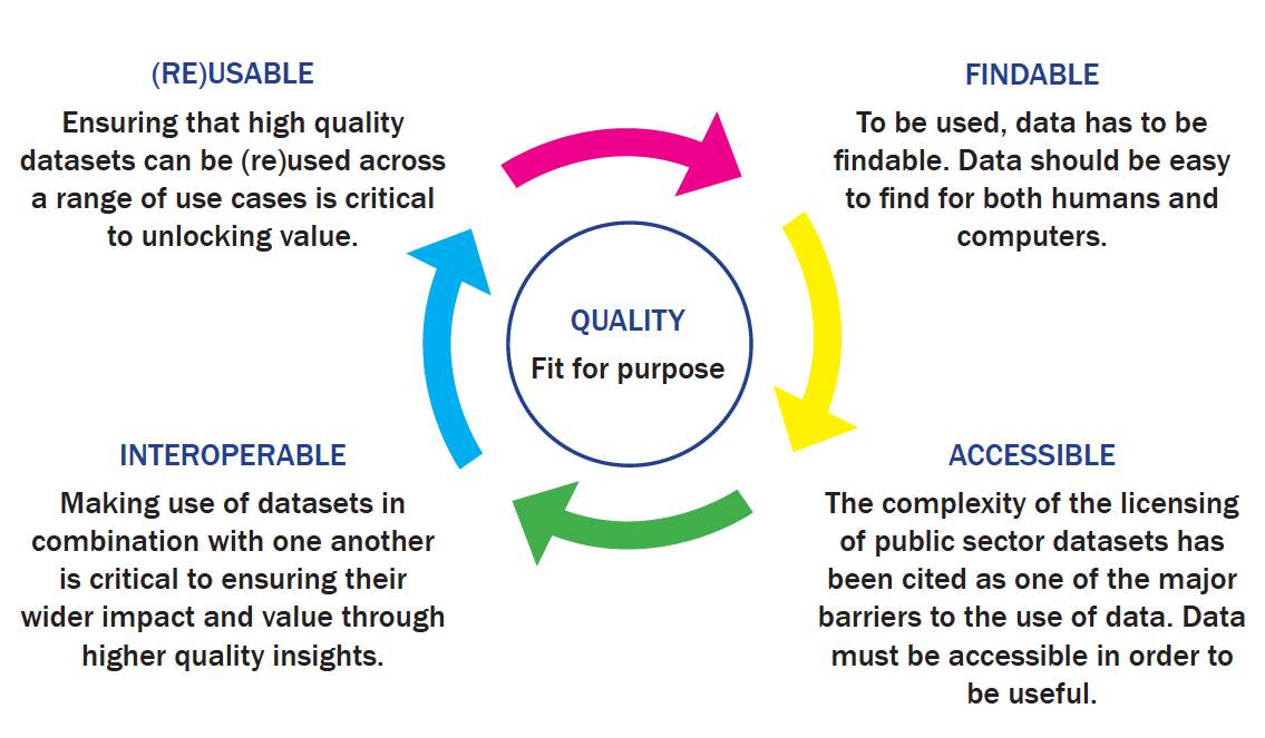
Our future is Q-FAIR
Working closely with our partner bodies and the Department for Environment, Food and Rural Affairs (Defra), the commission funded a data improvement programme that sought to tackle some of the shared data challenges faced by each of the organisations. The term ‘data improvement’ is very broad, so we adopted the FAIR principles to help structure and communicate our aims; to understand what is needed to make the data more:
- Findable
- Accessible
- Interoperable
- Reusable
Using this FAIR approach also emphasised the importance of ensuring the data is of appropriate quality and is fit for purpose, before you do anything else.
- Quality
In short, improvements to data must be Q-FAIR.
Using this FAIR approach also emphasised the importance of ensuring the data is of appropriate quality and is fit for purpose, before you do anything else.
In our data improvement programme, we went beyond the Q-FAIR acronym to establish requirements and recommendations associated with the Q-FAIR principles, which we called the Q-FAIR Framework. This helped us to establish a holistic view of improved data supply from the perspectives of the data itself, the organisation creating the data and the organisations as collective suppliers to the UK.
Applying the Q-FAIR Framework in our data improvement programme therefore gave us a benchmark of our public sector geospatial supply and enabled us to deliver some significant improvements to the foundations of geospatial data held by our partners. This has included:
- Developing a harmonised data exploration license for our partner body data assets to enable anyone to freely access their data for research, development and innovation purposes.
- Establishing a core set of partner body licensing principles for ongoing review using a shared language and definitions, to improve licence compatibility and allow end-users to more easily combine data.
- Identifying and selecting standards for partner body metadata records and catalogue services to allow greater interoperability between datasets.
- Establishing a data-sharing agreement between partner bodies to improve access and interoperability of data and structures.
- Building an alpha service and testing the concept of correlation relationships, a service that would allow an authoritative join between two datasets to be shared and published.
- Publishing best practice guidance around archive data capture and digitisation, to support considerations for further work to explore the use of new technology (such as machine learning and natural language processing) and crowdsourcing as means to extract useful insight from archived data more efficiently.
- Improving our understanding of the UK’s coastlines through a project focused on understanding the data landscape of agencies involved in the collection and use of geospatial data in the coastal zone.
We will be publishing more on each of these initiatives along with our initial Q-FAIR benchmark of the state of data supply.
Through the data improvement programme, we saw the clear benefits of using the Q-FAIR framework as a common language between the Geo6, the Geospatial Commission and our wider stakeholders. It helped to map (if you excuse the pun) the context for data improvements to the identification and realisation of the specific actions to bring improvements about.
Building the ambition
We now intend to expand the scope of our ambitions for improved UK public sector geospatial data.
The right improvements, to the right data sets, at the right time, and with the right connections to other data, has so much potential.
Based on the learnings from the data improvement programme we are developing our Q-FAIR Framework through a new programme of work. This programme aims to develop a systemic and sustained approach that will advance the supply of the geospatial data managed by the public sector now and in the future. This will be achieved through an objective benchmarking against Q-FAIR principles linked to business plans, standards and the regulatory framework to bring improvements about. We will start with our six partner bodies and build-out across the public sector.
This work will not only help us to set our priorities for the future, but it will also enable us to track our collective progress, aligned to national and international initiatives such as the UN’s Sustainable Development Goals and Integrated Geospatial Information Framework (IGIF)
The right improvements, to the right data sets, at the right time, and with the right connections to other data, has so much potential. It will allow us to make the right decisions that will create economic value, enabling the levelling up agenda and serving the country’s needs in an intelligent and data-informed way. Resulting in more services that are better informed by location and are tailored for the public across the country wherever you are. We are looking forward to going on that journey with you!
Resources and tools to help you manage and share geospatial data in a FAIR way
The Geospatial Commission has brought together a range of tools and best practice guidance aimed at helping those involved in the management and sharing of geospatial data to ensure their data is FAIR (findable, accessible, interoperable and reusable).
- The authoritative data assessment tool – to help identify data publishing organisations and datasets which can be considered trustworthy to users and enable them to find datasets associated with increased levels of confidence
- The data sharing assessment (DSA) tool – to apply standard criteria to help data publishers release data responsibly
- Search engine optimisation for publishers: Best practice guide
- Linked identifiers schemes: Best practice guide – to help make data more interoperable
- Extracting data from archives: Best practice guide
- Geospatial glossary
- Finding geospatial data
All of the above are available online: www.gov.uk/government/collections/best-practice-guidance-and-tools-for-geospatial-data-managers
Callum Irving, Senior Data and Standards Advisor, Geospatial Commission
geospatialcommission@cabinetoffice.gov.uk @GeospatialC