Mapping Alaska’s coastline
Hanna Hellstroem, and Cristina Mauri, Leica Geosystems part of Hexagon, with Andres Vargas, Technical Expert at NV5 Geospatial
THE Alaska Coastal Mapping Initiative is driven by the 2019 Presidential Memorandum on Ocean Mapping of the US Exclusive Economic Zone and the Shoreline and Nearshore of Alaska.
The long-term goal is to create a seamless coastal map of the state by 2030 with a focus on the connection between the inland terrain and the offshore subsurface environment. The programme places an emphasis on the use of bathymetric lidar technology.
The long-term goal is to create a seamless coastal map of the state by 2030 with a focus on the connection between the inland terrain and the offshore subsurface environment. The National Oceanic and Atmospheric Administration (NOAA) contracted the client, NV5 Geospatial, to map the shoreline in an extremely complex area of Southeast Alaska as part of the NOAA’s national geodetic survey (NGS) coastal mapping programme. The shoreline mapping required the client to collect subsurface bathymetric measurements as well as nearshore elevation data.
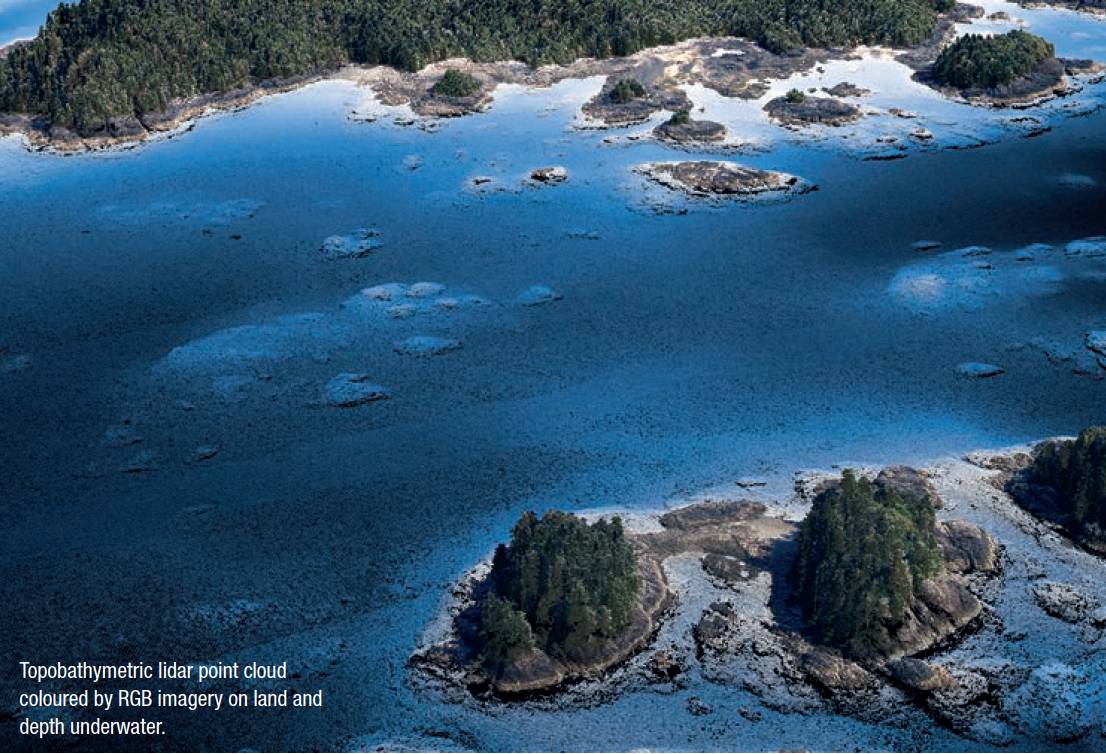
Despite Alaska’s famously turbid water and poor flying conditions, the project used integrated airborne Leica’s Chiroptera 4X and HawkEye 4X lidar sensors to capture the onshore topographic and shallow-water bathymetric data sets. It meant seafloor details to depths of 16-20 m could be accurately mapped for the first time.
The Alaska coastline had been poorly mapped previously due to a variety of conditions, including frequent rain and cloud cover, dramatic tidal swings, and turbid waters caused by dynamic wave action. The advantages of accurately mapping the shoreline are many – safer ship navigation, more efficient coastal resource management, better modelling of storm surges and coastal flooding, and improved benthic habitat stewardship.
The airborne data collection would also immediately impact the coastal mapping project itself. The near-shore bathymetric measurements would be supplied to the sonar-equipped vessels also taking part in the survey initiative to keep them operating in deeper waters. The NOAA’s aim is to get very accurate and precise data to promote the safety of all the vessels working in these complicated environments.
The Alaska coastline had been poorly mapped previously due to a variety of conditions, including frequent rain and cloud cover, dramatic tidal swings, and turbid waters caused by dynamic wave action. With the client based in the USA, the use of airborne topographic and bathymetric lidar sensors was a huge benefit as they are capable of acquiring onshore terrain and offshore water depth data simultaneously. It would be a significant time saver in environments where suitable flying conditions are limited.
Two project areas were assigned, including about 630 miles of rugged shoreline in the Revillagigedo Channel near Ketchikan, Alaska, a project area totalling 350 square miles in an extreme fjord-filled landscape. Project specifications called for capturing the aerial bathymetric lidar points with a minimum density of three points per square metre (ppm) within plus or minus two hours of low tide.
It was also requested to precisely delineate the land-water boundary at 25cm four-band multispectral optical imagery at low tide within 30 days of lidar operations. It meant the target acquisition window was between May and October 2021, with the Chiroptera 4X and HawkEye 4X integrated lidar system sent to Alaska for this aboard a Cessna Caravan.
The Chiroptera 4X is a dual-laser designed specifically for the simultaneous collection of high-resolution terrestrial elevation and shallow-water bathymetric points. The bathymetric laser operates in the visible green portion of the spectrum, which penetrates the water column to a nominal depth of 30m with 0.15cm vertical accuracy at a 5-ppm density in clear waters and during ideal surveying conditions.
The near-infrared topographic laser has a typical vertical accuracy of 15cm. While it is a standalone system, the HawkEye 4X module is a companion device to collect deeper bathymetric data when integrated, typically adding 40-50 % additional depth penetration with an accuracy exceeding IHO order 1.
Integration of the sensors enabled onshore, shallow-, and deeperwater data in a single flight to be acquired, maximising the handful of good flying days available.

Capturing data in extreme conditions
In preparing for deployment, the client knew the harsh conditions in Alaska would be a challenge that required special procedures. Most notable were the low-lying clouds that limited flight operations, as well as the nearly relentless winds that kept the waters dynamic and turbid. Another issue was the dramatic terrain of the fjord landscape that sees the shoreline in many places rising several hundred feet vertically out of the water.
The harsh conditions in Alaska would be a challenge... most notable were the low-lying clouds that limited flight operations, as well as the nearly relentless winds that kept the waters dynamic and turbid. Another issue was the dramatic terrain of the fjord landscape that sees the shoreline in many places rising several hundred feet vertically out of the water.
Finding flat ground for the placement of survey control markers was difficult in the rugged topography covered by dense vegetation in many areas.
The team surveyed 164 points, including the mooring of buoys in the water. These buoys not only served as control points but also monitored water clarity and relayed these measurements to the team. This information proved critical in deciding daily where water conditions were suitable for airborne lidar operations.
Windy weather created choppy waters which increased turbidity, and the flight planners quickly noticed patterns in the wind-turbidity conditions.
Winds from certain directions roiled the water more severely than from others. In fact, the wind direction was nearly as important as wind speed in reducing water clarity.
Meteorological predictions helped give the crews an edge in planning the next day’s flights based on expected wind conditions.
Unexpected challenge
An unexpected challenge that required an onsite modification of airborne operations was related to the extreme terrain and cloudiness. NOAA specified a collection of ground elevation measurements for a half mile inland from the shore.
Unfortunately, in that half-mile distance, the fjord walls rose so precipitously that flights over the land would have to be conducted at a much higher altitude than over the water.
This case study was first published in Hydro International. Integration of the sensors enabled onshore, shallow-, and deeper-water data in a single flight to be acquired, maximising the handful of good flying days available.
With flights already limited by clouds, it was decided to operate the Chiroptera/ HawkEye system only over the water in some areas to focus on the acquisition of bathymetric data. Even in steep fjords, the oblique scanning angle of the Chiroptera terrestrial laser captured the shoreline, which was critical to the mapping project.
But for surveying farther inland, a second aircraft onsite with a dedicated terrestrial lidar was needed to capture the additional data at the higher altitude – when weather allowed.
Conclusion
Once the flight operations were completed, the data went to processing in order to extract and correct the elevation points for each flight line. This could then be used to generate the point clouds and normalise the Chiroptera and HawkEye data sets for integration.
A key aspect of this process was finding relatively flat seafloor surfaces in the overlap area between the Chiroptera shallow data and the deeper HawkEye measurements. Technicians used this as the cut line where the two point clouds were merged to create a seamless bathymetric data set from the shoreline down to a maximum of about 20m in depth, where the lidar penetration ended.
This bathymetric ‘extinction line’ at 20m in depth was critical to the next and ongoing phases of the Alaska Coastal Mapping initiative. The bathymetric and topographic lidar data will enable NOAA to carry on with the collection of multi-beam sonar [aboard vessels] in a safe manner.
Hanna Hellstroem, and Cristina Mauri, Leica Geosystems part of Hexagon