River condition assessments – How do they work?
Mike Hopkins MCInstCES, Managing Director, Storm Geomatics

WHY do we measure anything? Because we like using kit, see how accurate we can be, produce beautiful drawings, travel to different places, like solving problems?
Probably all these for the surveyor, however people who use our measurements want a starting point to build or improve from or use as a comparison over time.
Rivers and streams are the carriers of water to our reservoirs so for this reason alone it makes sense to measure and manage them to sustain a healthy supply.
A river in good condition has a variety of habitats and with that comes a healthy ecosystem with an abundance of species, a species-rich river is also an indicator of good water quality.
The latest State of Nature Report 2019 which is made up of data from 70 UK partners across research institutes, governments and non-government organisations reports that the indicator for 696 terrestrial and freshwater species shows a significant decline of 13% in average abundance since 1970 and has fallen by 6% over the past 10 years.
This is an important statistic as it proves that living conditions in the UK (and not just for the human species) are declining.
One of the reasons for this is the loss of habitat, and it is the river condition assessment (RCA) that can address this problem in the river corridor.
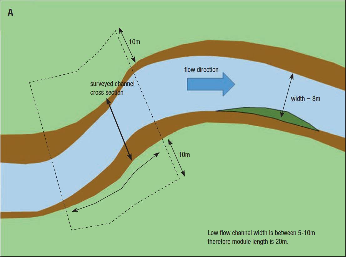
Diagram A: The different areas and survey extents for a channel width of between 5-10 m.
The RCA measures the current river condition and provides a baseline score. Analysis is then undertaken to determine interventions that could be made to the river to provide an uplift in the score, which is tested by scenario modelling within the RCA system.
Overview of the science behind it
Rivers and streams are the carriers of water to our reservoirs so for this reason alone it makes sense to measure and manage them to sustain a healthy supply.The RCA uses measurements from predominantly three different sciences – geospatial, hydrogeomorphology and ecology. Geospatial measurements define the river type and channel geometry that interlink with the hydrogeomorphology of the river channel and banks.
The interaction of these two sciences informs how the natural processes of a river can shape the inert materials that make up the channel into different habitats.
The ecology looks at the plant life within the river channel and banks which can score positively or negatively depending on their abundance and how they contribute to riverine habitats.
The revelation in merging the sciences is that you don’t need to be a geospatial surveyor, a hydrogeomorphologist or an ecologist to undertake an RCA, but you do need to take the RCA professional training which is done over a period of six weeks.
Geospatial measurements define the river type and channel geometry that interlink with the hydrogeomorphology of the river channel and banks.The course provides the relevant level of training in all three fields and trains you to determine which type of river you are measuring (type A to type M) and how to observe the 32 physical indicators that are sensitive to the final RCA score.
Areas of the river to survey with an example of a physical indicator
There are 13 river types that could be encountered in English rivers which are defined by a combination of their confinement in the river valley, planform, gradient and bed material.
For example, a river that has a bed material of sand and gravel, a low sinuosity index (fairly straight) and is partly confined i.e. has some potential to change its planform through natural erosion, would be a type H river.
Once the river type is set, the 32 physical indicators within the river channel are observed in modules that represent a length that is 20% of the study reach. Indicators provide a sample of the positive and negative influences that are natural or manmade within that reach. Each survey module length is a function of the river width – the wider the river, the longer the module length will be.
Each survey module length is a function of the river width – the wider the river, the longer the module length will be.Different areas of the river channel module are assessed independently as the indicators influence the score differently depending on where they are located. The example diagram A shows the different areas and survey extents for a channel width of between 5-10 m.
Observations within each of the areas is made on the features/indicators and a note is made about their abundance. Table 1 is an extract from the booking sheet that captures the presence of channel bed materials, which is one of the 32 indicators that influence the RCA score.
The RCA booking sheets for the different areas are methodically laid out and once the surveyor has completed 20 or 30 modules the coding and process becomes more familiar, and the surveyor becomes more focussed on the key indicators that they are looking for.
The final critical factor that has influence on the river condition score is the river geometry and this is where geospatial surveyors are likely to provide a more accurate result than non-surveyors. The final critical factor that has influence on the river condition score is the river geometry and this is where geospatial surveyors are likely to provide a more accurate result than non-surveyors.
This is because surveyors possess the skills and equipment to capture these measurements more accurately than an assessor equipped with a tape measure and ranging rod (the basic recommended tools for undertaking this part of the survey).
Diagram B shows the minimal measurements required for each module.
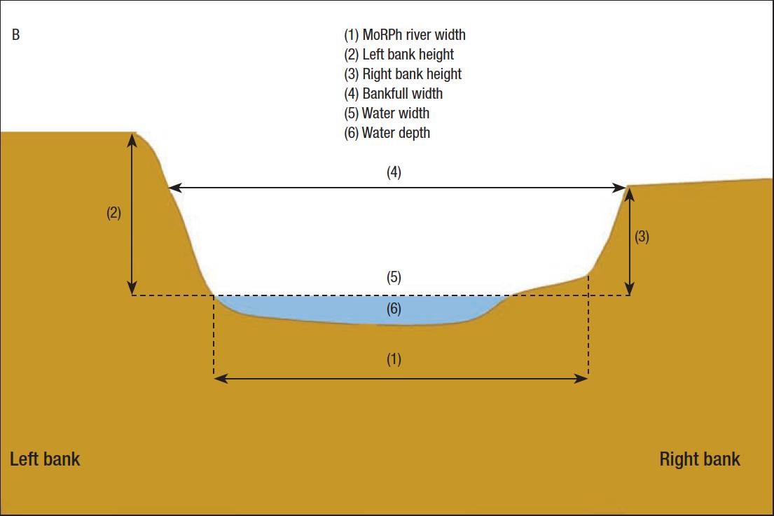
Diagram B: Showing the minimal measurements required for each module.
How the scoring system works
The final dataset of the channel geometry and the 32 indicators is entered into on online database which calculates a preliminary river condition score. Indicators summarise the ‘natural’ features as positive indicators and the human interventions and pressures as negative indicators. Each river condition indicator is automatically assigned a score from 0 to 4 (positive indicators) or 0 to -4 (negative indicators).
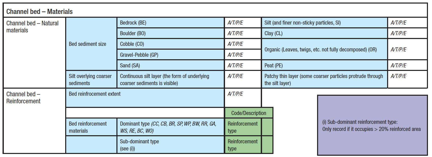
Table 1: Capturing the presence of channel bed materials.
These condition indicators not only feed into the preliminary condition score but they also provide information on why the reach has been assigned a particular condition, and where to focus effort when attempting to improve condition. The preliminary condition score is a numerical value and is based on the formula:
- River condition score = average of all negative river condition indicator scores + average of all positive river condition indicator scores.
Preliminary river condition score is then converted to a final river condition score which is expressed as one of five categories very poor, poor, moderate, good, and very good.
Geospatial surveyors should play their hand in this as they have the skills, aptitude, and attention to detail to provide high-quality assessments, not only in the built-environment but the environmental-environment too!This is derived from a lookup table which pitches the preliminary numerical score against the river type, however it can be moved down a category if the river channel is considered over-deep.
An over-deep river is one that has been modified to a point where it is less able to interact with its floodplain or riparian margins. It is calculated from the channel geometry which is why it is important to capture these measurements accurately.
Why a geospatial surveyor is well placed to carry out river condition assessments
River condition assessments are crucial to the restoration and preservation of rivers and streams in England.
They not only provide a baseline condition of the river but also reveal valuable information on how higher target conditions can be achieved by analysis of the positive and negative indicators.
There will be a high demand for these surveys as the Environment Act 2019 comes into force this November and resources will be needed to carry out the assessments. Geospatial surveyors should play their hand in this as they have the skills, aptitude, and attention to detail to provide high-quality assessments, not only in the built-environment but the environmental-environment too!
River condition assessments are crucial to the restoration and preservation of rivers and streams in England. They not only provide a baseline condition of the river but also reveal valuable information on how higher target conditions can be achieved by analysis of the positive and negative indicators.
Mike Hopkins MCInstCES Managing Director, Storm Geomatics
mike.hopkins@storm-geomatics.com
Illustrations and table ©Modular River Survey