
TRANSFORMING THE GEOSPATIAL LANDSCAPE
How AI, digital twins and reality capture are revolutionising surveying
The geospatial industry is undergoing a major transformation, fueled by emerging technologies that are revolutionising how spatial data is collected, analysed and applied. While innovation has always been a key driver in this field, the rapid adoption of AI, digital twins and reality capture technologies is accelerating progress like never before. Surveyors and geomatics professionals are leading this change, using advanced tools to improve accuracy, optimise workflows and provide valuable insights that inform infrastructure development and resource management. However, the industry faces the challenge of managing complex data, modernising workflows and addressing the needs of an ageing workforce, all while investing in the training and development of the next generation.
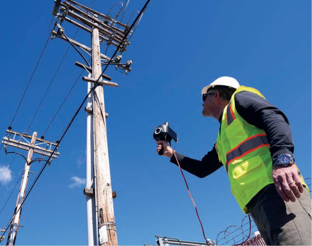
Distribution pole capture with the Looq qCam.
Artificial intelligence is reshaping geospatial workflows by automating complex tasks such as data classification, feature extraction and point cloud processing. Machine learning algorithms now analyse vast datasets with minimal manual effort, significantly improving operational efficiency. AI doesn’t replace surveyors, it empowers them to focus on higher-level tasks like decision-making and oversight. Surveyors remain essential in verifying AI-generated insights, ensuring precision and maintaining regulatory compliance in an increasingly digital environment. AI-powered automation enables rapid extraction of actionable insights from high-resolution imagery.
Advanced geospatial solutions optimise construction site monitoring and land surveying, while AI-driven analytics enhance asset performance and lifecycle management across infrastructure projects.
Dynamic, data-driven models of physical assets, known as digital twins, are revolutionising infrastructure monitoring and maintenance. Unlike static 3D models, digital twins are dynamic, continuously updated with real-time data, providing a living representation of assets like bridges, power grids and urban environments. These virtual replicas facilitate predictive maintenance, optimise operations and enhance decision-making for engineers and utility managers. Digital twin technology is making a significant impact on utility vegetation management, enabling power companies to efficiently monitor and manage tree growth around power lines. Transportation agencies use digital twins to track road and rail infrastructure conditions, while architects and engineers leverage them to simulate and optimise building performance. Real-time infrastructure management supports cities and industrial facilities, improving sustainability and operational efficiency.
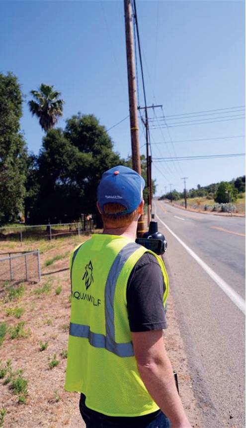
Aquawolf CEO Alex Richards demonstrates how he quickly captures field data for a client using the Looq AI qCam.
Reality capture – the process of creating highly detailed digital representations of the physical world – is the foundation of digital twins and AI-driven geospatial applications. Advances in photogrammetry, mobile mapping and LiDAR technology now allow for the creation of survey-grade 3D models with unprecedented precision. Vehicle-mounted systems enable rapid and accurate 3D mapping for infrastructure projects, while mobile mapping solutions support large-scale roadway surveys.
Advanced software allows construction professionals to generate detailed 3D scans from drone and terrestrial photogrammetry or LiDAR data, transforming reality capture into engineering-grade digital models used in construction, asset management and urban planning.
Several notable projects have successfully utilised technologies from Looq AI, Trimble, Autodesk and Bentley, demonstrating the transformative impact of these tools in the geospatial and infrastructure sectors.
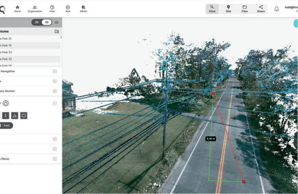
Looq AI’s AI-powered digital twin platform enables teams to interact with accurate models and data, improving decision-making and operational efficiency. In a project with Central Hudson Gas and Electric, Looq AI used its handheld photogrammetric camera to capture 3D digital twins of distribution poles and substations. This approach delivered highly accurate data at a lower cost compared to traditional LiDAR surveys. Looq AI’s technology also helped Aquawolf, a subsidiary of Mammoth Energy Partners, capture survey-grade point clouds on-site, reducing project costs and processing time by 30%.
In Switzerland, Strabag employed Trimble technology for a road reconstruction project. Collaborating with Swiss Trimble distributor MEB Group, Strabag utilised Trimble solutions for model-based execution planning, execution, site management and supplier coordination. This approach streamlined workflows and enhanced project efficiency, demonstrating the role of advanced geospatial technologies in improving infrastructure projects across Europe.
In an urban redevelopment project in Chicago, city planners used Autodesk’s Civil 3D and InfraWorks to create detailed digital twins of the cityscape. These tools enabled surveyors to integrate high-resolution reality capture data with existing GIS maps, streamlining the planning and approval process. The digital twins provided realtime visualisation of proposed infrastructure changes, helping stakeholders make data-driven decisions on road improvements and green space integration. This project exemplifies how Autodesk’s technology can enhance urban planning through dynamic digital twins.
EPRI’s Incubatenergy Labs paired Central Hudson Gas and Electric with Looq AI in 2024 to enhance infrastructure analysis.
infrastructure projects Bentley Systems has contributed to several significant infrastructure projects, including the Midland Mainline Electrification (MMLE) Programme in England, where SPL Powerlines UK utilised Bentley’s ProjectWise to establish a connected data environment. This approach streamlined collaboration across 20 design organisations, facilitating the installation of 447km of overhead line equipment. Similarly, in the Philippines, Bentley’s iTwin Capture, OpenBridge and OpenRoads were employed to develop a mixed reality digital twin for the NLEX-SLEX connector road project, improving construction logistics by 40% and reducing travel time between northern and southern Manila.
The demand for skilled geospatial professionals continues to grow, yet the industry faces a looming workforce shortage. With nearly half of today’s surveyors expected to retire within the next 15 years, attracting and training new talent is a critical priority.
While incidents like the recent power supply failure at Heathrow Airport highlight vulnerabilities in critical infrastructure, they also underscore the urgent need for more proactive technologies to enhance resilience. Digital twin systems, for instance, can help play a vital role in predicting and preventing such failures by offering real-time monitoring and predictive maintenance. These systems can help enable the identification of potential issues before they escalate, supporting more resilient, smarter infrastructure management.
As governments and industries worldwide increasingly focus on infrastructure resilience, AI and digital twin technologies are poised to future-proof critical national assets. They promise to improve operational efficiency, enhance security and ensure the continuity of essential services, reducing the likelihood of costly disruptions.
Despite the immense potential of AI, digital twins and reality capture, adoption has historically been hindered by challenges related to data processing and integration. In the past, creating digital twins required extensive manual input and costly workflows. However, recent advancements in cloud-based processing, automation and agile photogrammetry are lowering these barriers. AI-driven feature extraction and automated CAD linework generation are accelerating workflows, reducing costs and making high-precision geospatial insights more accessible than ever. Solutions that simplify digital twin creation through automated AI-driven segmentation and feature extraction are now available. Cloud-based platforms facilitate data sharing and collaboration, streamlining project coordination and enabling seamless integration of reality capture and GIS data. These advancements are making high-quality geospatial insights more attainable for professionals across industries, driving innovation at scale.
The demand for skilled geospatial professionals continues to grow, yet the industry faces a looming workforce shortage. With nearly half of today’s surveyors expected to retire within the next 15 years, attracting and training new talent is a critical priority. To address this challenge, educational institutions and industry leaders are expanding programs in geospatial sciences, AI and digital modeling. Surveyors are no longer just data collectors – they are essential problem-solvers. As the industry evolves, surveyors will play increasingly strategic roles in infrastructure planning, climate resilience and urban development. By embracing new technologies, they can enhance their expertise and ensure that the built environment is safe, sustainable and efficiently managed.
The geospatial industry is evolving into an interconnected ecosystem, where traditional boundaries between surveying, GIS and engineering are blurring. AI, digital twins, and reality capture are fostering collaboration and improving decision-making across sectors. Surveyors remain central to this transformation, providing the foundational data that powers smarter, more sustainable infrastructure. As these innovations gain traction, the role of surveyors and geomatics professionals will continue to expand.
The convergence of AI-driven analytics, immersive digital twins and high-precision reality capture is shaping a smarter, more connected world where geospatial expertise is more vital than ever.
The future of geospatial innovation is brighter than ever, driven by the remarkable capabilities of AI, digital twins and reality capture technologies. These advancements are transforming the landscape of infrastructure management, making processes more efficient, cost-effective and sustainable. As the industry continues to embrace these innovations, the role of surveying professionals in shaping the world of tomorrow will remain indispensable.
Article References and Citations:
- Computing. (2025). AI-driven improvements in geospatial data analysis.
- UK Parliament (2024). Digital twins for infrastructure resilience.
- Trimble. (2023). Road reconstruction in Switzerland.
- SPL Powerlines UK shortlisted for Bentley Systems’ 2024 Going Digital Awards. Rail Business Daily.
- Looq AI Project. (2024). Collaborating with Central Hudson Gas and Electric.
- Power (2025) - Heathrow power outage and infrastructure failure.
- Autodesk source: autodesk.com/autodesk-university/class/Chicago-Model-Infrastructure-Future-Using-InfraWorks2017?utm_source=chatgpt.com