
SURVEYING THE TRUTH
The field of geospatial surveying has undergone a technological revolution over the last century. From early theodolites and chains to the rise of GNSS, LiDAR, UAVs, SLAM (simultaneous localisation and mapping) scanning and AI-powered processing, the profession has been redefined by innovation. Yet, with this progress has come a growing disconnect between technology and expertise, as manufacturers and resellers increasingly market fast, automated and seemingly effortless solutions to industries that may not fully understand what constitutes survey-grade data. So much is hidden behind the veil of survey equipment technology and software. This summary of the last 100 years of geospatial survey evolution will give you an insight.
This article explores the true evolution of geospatial surveying – not just as a timeline of technological advancements but as a critical examination of where expertise fits in a world of seemingly ‘push-button’ solutions. We delve into the real impact of GNSS in the 1990s, the breakthroughs of LiDAR in the 2000s and how the 2010s to the present day have introduced high-definition photogrammetry, SLAM scanning and integrated geospatial intelligence.
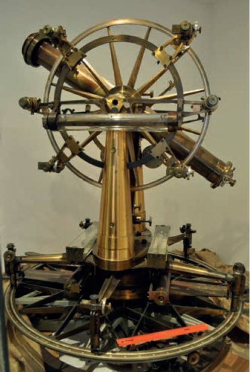
The Great Theodolite. © Chief Directorate: National Geo-spatial Information, South Africa.
However, while technology plays a crucial role, expert geospatial surveyors remain essential in ensuring the right methodologies, equipment and software are applied appropriately to meet the specific needs of each project.
Geospatial surveying has undergone a remarkable transformation since 1900, evolving from manual, labour-intensive methods to highly precise, automated and integrated processes. Advances in technology, from early photogrammetry to satellite positioning and laser scanning, have revolutionised the field.
However, while technology plays a crucial role, expert geospatial surveyors remain essential in ensuring the right methodologies, equipment and software are applied appropriately to meet the specific needs of each project. This article explores the history of geospatial surveying, the key technological developments that have shaped the profession, and the vast range of tools and expertise required in modern surveying.
At the beginning of the 20th century, surveying relied on traditional instruments such as chains, tapes and theodolites to measure distances and angles accurately.
At the beginning of the 20th century, surveying relied on traditional instruments such as chains, tapes and theodolites to measure distances and angles accurately. These tools were used to establish boundary lines, create maps and support engineering projects. In 1900, Berger & Sons produced a catalogue showcasing these instruments, demonstrating their importance to the profession.
During this period, the emergence of aerial photography laid the foundation for photogrammetry – the science of taking measurements from photographs. Early aerial surveys were conducted using balloons, kites and even pigeons filled with cameras to capture overhead images. By the 1920s, aeroplanes had become the primary platform for aerial surveys, significantly improving the detail and accuracy of geospatial data collection.
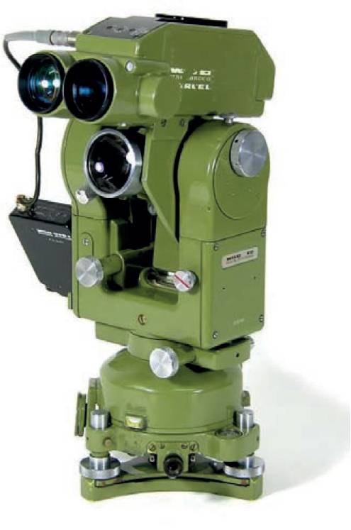
A Wild T2 theodolite with a Distomat EDM device.
The 1950s and 1960s saw the introduction of electronic distance measurement (EDM) devices, which revolutionised surveying by using electromagnetic waves to measure distances.
The 1950s and 1960s saw the introduction of electronic distance measurement (EDM) devices, which revolutionised surveying by using electromagnetic waves to measure distances. Instruments such as the Tellurometer, developed in the 1950s, enabled surveyors to measure long distances with greater accuracy and efficiency than traditional methods.
Another major breakthrough came with the launch of Sputnik in 1957, marking the beginning of satellite geodesy. Satellites quickly became instrumental in military surveillance, cartography and global communications, significantly enhancing the precision and scope of geospatial data collection.
The 1970s introduced total stations, which combined electronic theodolites with EDM technology. These instruments allowed surveyors to measure angles and distances simultaneously while recording data electronically, streamlining workflows and improving efficiency. At the same time, GIS was emerging as powerful tools for managing, analysing and visualising spatial data. Initially developed in the 1960s and 1970s, GIS has since become integral to geospatial surveying, enabling advanced spatial analysis and data-driven decision-making across a wide range of applications.
While satellite positioning had been in development since the launch of Sputnik in 1957, it was in the 1990s that GNSS became a fully operational and accessible technology for surveyors worldwide.
The 1990s marked a transformative period in geospatial surveying, with the widespread adoption of Global Navigation Satellite Systems (GNSS). While satellite positioning had been in development since the launch of Sputnik in 1957, it was in the 1990s that GNSS became a fully operational and accessible technology for surveyors worldwide.
The United States’ Global Positioning System (GPS), originally developed for military applications, became fully operational in 1995, offering a global, continuous and highly accurate positioning service. This was the first time surveyors could determine their precise location anywhere on Earth without relying on traditional triangulation methods or ground-based infrastructure.
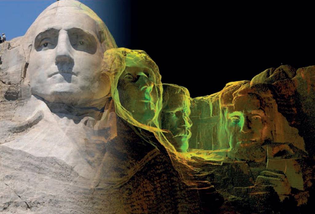
Early scans of Mount Rushmore. ©CyArk
However, GPS was only the beginning. As other nations recognised the strategic importance of satellite navigation, additional GNSS constellations were developed:
- GLONASS (Russia) – Initially launched in the 1980s, but fully restored to global coverage by 1996.
- Galileo (European Union) – The first satellites were launched in the late 1990s as a civilian-operated alternative to military-controlled systems, although full operational status wasn’t achieved until the 2010s.
- BeiDou (China) – Initially developed as a regional navigation system, with its first satellites launched in the late 1990s.
By the late 1990s, dual-frequency GNSS receivers became commercially available, allowing surveyors to access L1 and L2 signals for greater positioning accuracy, even in challenging environments. This was a significant improvement over single-frequency receivers, which were more susceptible to atmospheric interference.
GNSS revolutionised the way geospatial professionals conducted surveys, particularly in large-scale and remote projects where traditional methods were impractical. Some key advancements included:
Real-time kinematic (RTK) GNSS – introduced in the 1990s, RTK allowed surveyors to achieve cm-level accuracy in realtime using a base station to provide differential corrections.

Ben Kacyra. The godfather of terrestrial 3D laser scanning; founder of Cyra Technologies in 1996 and CyArk nonprofit organisation in 2003. He sadly passed away in September 2024.
Post-processed kinematic (PPK) GNSS – enabled high-precision positioning by applying corrections after field data collection, making it useful for remote locations where real-time corrections were unavailable, or high-accuracy survey control either side of tunnels or obstructions.
Continuous operating reference stations (CORS) – established in the 1990s, these stations provided a network of permanent GNSS receivers, enabling high-accuracy positioning without the need for a dedicated base station.
By the end of the decade, GNSS had become an essential tool for topographic surveying, construction, engineering and geodetic measurements. Its ability to provide consistent, precise and globally available positioning data meant that GNSS would soon become the backbone of modern geospatial surveying.
Surveying roads, railways and power lines with high precision.
While GNSS was transforming positioning accuracy, the 2000s saw the rise of light detection and ranging (LiDAR) as a breakthrough in high-resolution 3D data capture. Though LiDAR technology had been in development since the mid-20th century, it was in the 2000s that it became widely adopted for both airborne and terrestrial applications in geospatial surveying.
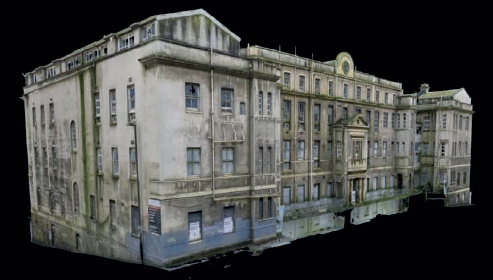
A textured meshed model from a photogrammetry survey. ©Terra Measurement
Airborne LiDAR systems first saw widespread use in the early 2000s as advancements in laser technology, GPS and inertial measurement units (IMUs) improved accuracy and efficiency. Mounted on aircraft, helicopters and later UAVs, LiDAR sensors emitted rapid laser pulses to measure distances to the Earth’s surface, producing dense, high-resolution point clouds. Key developments in airborne LiDAR during the 2000s included:
- High-pulse rate sensors – LiDAR systems became capable of emitting hundreds of thousands of laser pulses per second, vastly improving the density and detail of captured data.
- Full-waveform LiDAR – capturing the entire return signal from laser pulses allowed surveyors to extract more detailed information about vegetation, terrain and built environments.
- Integration with GNSS and IMUs – combining LiDAR with precise positioning data from GNSS and IMUs enabled the creation of highly accurate digital elevation models (DEMs), digital terrain models (DTMs) and 3D surface models.
Airborne LiDAR became particularly valuable for:
- Forestry and environmental monitoring – mapping tree canopies and ground elevation beneath dense vegetation.
- Flood risk and hydrological modelling – generating accurate terrain models for floodplain and coastal studies.
- Archaeology – detecting buried structures and ancient landscapes beneath dense forest cover.
- Infrastructure and transport planning – surveying roads, railways, and power lines with high precision.
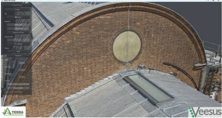
Alongside airborne applications, terrestrial LiDAR scanning became a powerful tool for capturing detailed 3D models of buildings, structures and infrastructure. These scanners, mounted on tripods or vehicles, enabled highly precise, high-density point cloud capture for complex environments. Significant advancements in terrestrial LiDAR during the 2000s included:
- Phase-based and time-of-flight scanners – two distinct LiDAR technologies emerged, with phase-based scanners excelling in short-range high-precision applications, and time-of-flight scanners being more effective for long-range surveys.
- Mobile mapping systems (MMS) – vehicle-mounted LiDAR combined with GNSS and IMUs allowed for rapid 3D data capture along roads and rail corridors.
- High-resolution 360° scanning – enabled the detailed documentation of heritage buildings, tunnels and industrial sites.
- Heritage and conservation – creating highly detailed 3D models of historic buildings for documentation, restoration and digital archiving.
- Engineering and construction – capturing as-built conditions for clash detection, BIM integration and structural monitoring.
- Industrial and offshore – providing unprecedented detail and accuracy for engineering and structural assessments.
By the end of the 2000s, LiDAR had become a mainstream geospatial technology, supplementing and, in some cases, replacing traditional surveying methods.
By the end of the 2000s, LiDAR had become a mainstream geospatial technology, supplementing and, in some cases, replacing traditional surveying methods. The integration of LiDAR with GNSS, UAVs and advanced processing software enabled faster and more detailed 3D geospatial data acquisition than ever before. What made LiDAR particularly revolutionary was its ability to:
- Penetrate vegetation – airborne LiDAR could distinguish ground elevation even in dense forests, making it invaluable for archaeology and environmental surveys.
- Generate highly detailed 3D models – urban planning, infrastructure monitoring and conservation efforts benefited from high-resolution spatial data.
- Reduce fieldwork time – large areas could be scanned in hours, rather than requiring weeks of manual surveying.
- Increased accuracy of measured building surveys – rather than just hundreds of measured points with assumptions and duplication of feature, a point cloud would contain billions of points, leaving nothing to question.
With both airborne and terrestrial applications, LiDAR established itself as a critical tool for precision mapping, setting the stage for its further evolution in the 2010s with real-time processing, UAV integration and SLAM-based mobile mapping.
Since 2010, geospatial surveying has undergone another wave of transformation, driven by high-definition digital photogrammetry, SLAM scanning and integrated multi-sensor technologies. These advancements have redefined how surveyors capture, process and analyse geospatial data, enabling unprecedented levels of precision, automation and efficiency.
While photogrammetry has been in use for over a century, the advent of ultra-high-resolution digital cameras, powerful computing and AI-driven software algorithms has revolutionised the field. The ability to process thousands of overlapping images has led to the creation of rich, detailed 3D models that were previously only possible using laser scanning.
Key developments in modern photogrammetry include:
- Structure-from-motion (SfM) algorithms: These allow thousands of high-resolution images to be processed into dense point clouds and photorealistic 3D models, without the need for direct laser measurements.
- Ultra-high-resolution sensors: Modern cameras now capture images in excess of 100 megapixels, allowing for cm-level accuracy in survey-grade photogrammetric models.
- Cloud-based and GPU processing: Advances in computing have dramatically reduced processing times, enabling near real-time creation of orthophotos, 3D meshes and digital surface models (DSMs).
- AI-assisted feature extraction: Machine learning algorithms can now automatically detect, classify and extract features from photogrammetric datasets, streamlining analysis.
Photogrammetry is now widely used in:
- Heritage conservation – creating digital twins of historic buildings for documentation and restoration.
- Infrastructure and engineering – generating accurate 3D site models for BIM (building information modelling) workflows.
- Topographic surveys – producing large-scale digital terrain models (DTMs) with unprecedented accuracy.
The combination of high-resolution cameras, precise GNSS positioning and AI-driven processing has elevated photogrammetry to a level where it can now rival LiDAR in certain applications, making it a vital tool in modern geospatial surveying.
One of the most significant advancements in recent years has been the development of simultaneous localisation and mapping (SLAM) technology. Unlike traditional LiDAR or photogrammetry, which require fixed reference points or GNSS, SLAM-based systems can build real-time 3D maps while the operator moves through an environment. SLAM has revolutionised surveying in indoor, underground, and GNSS-denied environments, such as:
- Tunnels and mines – SLAM scanners can map underground spaces where GNSS signals cannot reach.
- Dense urban areas – multistorey buildings, enclosed courtyards and construction sites can be surveyed quickly and accurately.
- Forests and vegetation – SLAM can generate terrain models even under thick tree canopies, where GNSS positioning is unreliable.
- Heritage and archaeology – SLAM allows for rapid, noninvasive mapping of historic buildings, ruins and excavation sites.
Advancements in SLAM scanning include:
SLAM technology has dramatically reduced the time required for complex 3D surveys, making it a go-to solution for high-speed, high-efficiency mapping.
- Backpack and handheld LiDAR systems – compact, mobile scanners such as the NavVis VLX and GeoSLAM ZEB series allow surveyors to walk through a site and generate real-time 3D maps.
- Integration with UAVs – SLAM is now being incorporated into drone-based LiDAR systems, enabling 3D mapping in GPS-denied environments such as forests, tunnels and industrial sites.
- AI-enhanced SLAM algorithms – modern SLAM software can correct for Drift errors, improving the accuracy of the final model.
SLAM technology has dramatically reduced the time required for complex 3D surveys, making it a go-to solution for high-speed, high-efficiency mapping.
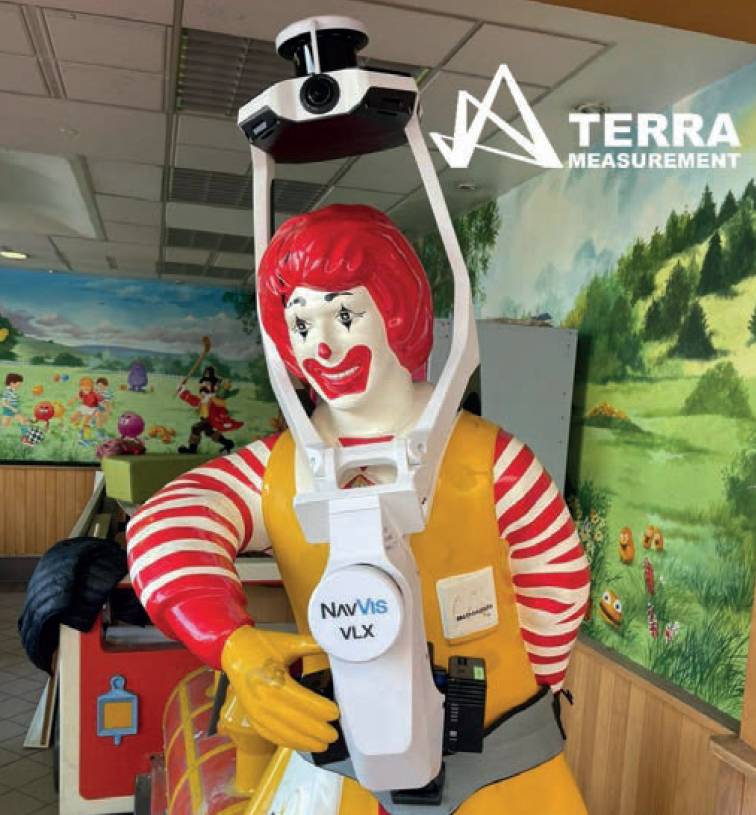
The NavVis VLX SLAM scanner – not quite sure who the clown wearing it is. ©Terra Measurement
Unmanned aerial vehicles (UAVs), or drones, have continued to evolve, moving beyond traditional photogrammetry to carry a wide array of advanced sensors. The most significant advancement is not the drones themselves but the miniaturisation of high-precision payloads, allowing UAVs to perform multi-sensor geospatial surveys. Modern UAVs now support:
- High-resolution cameras – capturing ultra-high-definition imagery for photogrammetry and orthophoto generation.
- LiDAR sensors – UAV-mounted LiDAR systems now provide survey-grade 3D point clouds with millimetre accuracy.
- Ground penetrating radar (GPR) – UAVs equipped with lightweight GPR sensors can detect subsurface features, useful for archaeology, geotechnical engineering and utility mapping.
- Thermal cameras – used for infrastructure inspections, environmental monitoring and energy efficiency analysis.
- Bathymetric sensors – UAVs can now carry laser and sonar-based bathymetric sensors to survey shallow water bodies and coastal areas.
These multi-sensor UAVs enable surveyors to capture diverse datasets simultaneously, reducing fieldwork time and improving survey efficiency.
The modern era of geospatial surveying is no longer about individual instruments – it is about integrated, multi-source data collection, processing and analysis.
The challenge moving forward will not just be about capturing data, but making sense of it. The future of surveying will rely on geospatial intelligence – turning vast amounts of data into actionable insights that drive smart decision-making across industries.
Key trends shaping the industry include:
- BIM and digital twins – The integration of survey data with 3D models of infrastructure, buildings and entire cities, enabling real-time monitoring and simulation.
- GNSS-integrated LiDAR and SLAM – combining high-precision positioning with real-time 3D scanning, allowing for accurate, mobile mapping solutions.
- Sensor fusion – merging UAV photogrammetry, terrestrial LiDAR and underground GPR data into a single, unified geospatial dataset.
- AI-driven processing and automation – AI-powered software can now automatically classify, extract and analyse geospatial features, reducing manual data processing time.
- Cloud-based geospatial collaboration – platforms like Veesus’ Arena4D and Nira allow surveyors to store, visualise and share 3D datasets in real-time, facilitating remote collaboration.
- IoT and smart monitoring systems – the Move Solutions wireless monitoring network provides live data on structural health, ground movement and environmental conditions.
These technologies are transforming geospatial surveying from a data collection process into an intelligent decision-making system, where real-time insights drive infrastructure management, environmental planning and digital asset management.
Veesus is a so›ware company that provides point cloud solutions for businesses. Its so›ware enables users to capture, view, edit and share 3D data.
From high-definition digital photogrammetry and UAV-based multi-sensor surveys to SLAM-enabled real-time 3D mapping, the last decade has been one of unprecedented innovation in geospatial surveying. Looking ahead, we can expect:
- Even smaller, more powerful sensors – future survey instruments will continue to shrink in size while increasing in precision.
- AI-powered automation – more processes will be handled by machine learning, reducing the need for manual data classification and processing.
- Augmented reality and virtual reality – survey data will be visualised in immersive 3D environments, allowing clients and stakeholders to interact with geospatial data in new ways.
- Fully autonomous survey platforms – UAVs, ground-based robots and AI-driven systems will conduct surveys with minimal human intervention.
The challenge moving forward will not just be about capturing data, but making sense of it. The future of surveying will rely on geospatial intelligence – turning vast amounts of data into actionable insights that drive smart decision-making across industries. The geospatial revolution is far from over – it is only just beginning.
What is The Geospatial Edge?
The Geospatial Edge is a free-to-subscribe newsletter published on LinkedIn that explores the role, value and evolving landscape of geospatial surveys across sectors such as architecture, civil engineering, infrastructure, heritage conservation, estate management and environmental monitoring. It is aimed at professionals who do, or should rely on accurate geospatial data to make informed decisions.